Catalog Archive
Auction 199, Lot 359

Magnificent Decorative Chart of the Western Atlantic, with a Fascinating Provenance

"Terra Nova, ac Maris Tractus Circa Novam Franciam, Angliam, Belgium, Venezuelam Novam Andalusiam, Guianam, et Brasiliam / Terra Neuf, en de Custen van Nieu Vranckyck, Nieu Engeland, Nieu Nederland, Nieu Andalusia, Guiana en Venezuela", Wit, Frederick de

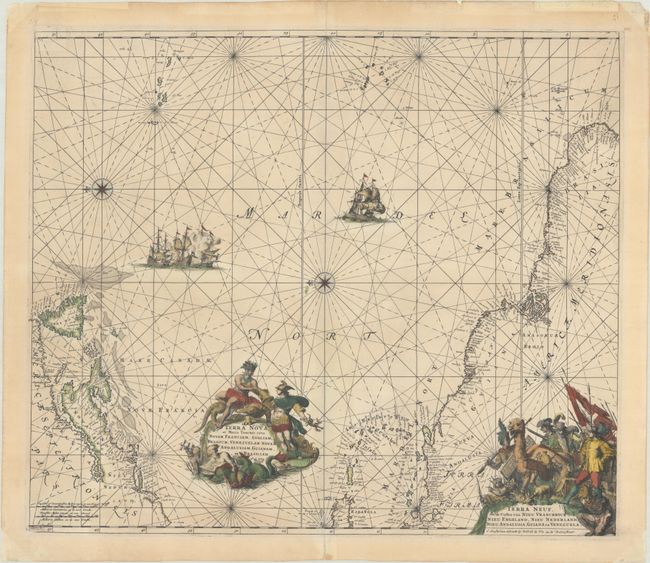
Subject: North Atlantic

Period: 1695 (circa)

Publication:

Color: Hand Color

Size:
21.9 x 18.9 inches
55.6 x 48 cm
Download High Resolution Image
(or just click on image to launch the Zoom viewer)

This magnificent sea chart of the western Atlantic Ocean shows the coastlines of North America from Cape Charles, Maryland to Newfoundland, and from the West Indies to the northern coast of Brazil. The chart is based on that of Theunis Jacobsz, circa 1650, with few changes except for an improved (although still rudimentary) depiction of the Chesapeake Bay. Oriented by two compass roses with north to the left; the Azores and Cape Verde Islands are at the top of the map. It is richly decorated with two large cartouches with the title in Latin and Dutch. The central cartouche is surrounded by Mercury, a native riding an alligator, mermen, and sea monsters. The corner cartouche with Dutch title features figures of explorers, natives, and exotic animals, including an armadillo. In the sea are sailing ships, including a raging sea battle, rhumblines, and two compass roses. This is the fourth state, with no printed plate number and the addition of sea names.

First published circa 1675, de Wit's sea atlas, Orbis Maritimus ofte Zee Atlas, contained 27 charts from the North Pole to North and South America. The charts all appear to have been engraved by Romain de Hooghe and are splendid examples of Dutch marine works. The atlas was reprinted with amendments by Louis Renard in 1715, by Reinier and Josua Ottens in 1739 and 1745, and finally by the widow of van Keulen in 1802.

Provenance: This map was a gift to the previous owner’s family from the van Perlsteins, a prominent Jewish family involved in the resistance during the Nazi occupation of the Netherlands. In 1942, at the request of the van Perlsteins, the previous owner’s family hid a Jewish couple in their home in Bussum for the remaining duration of the war. When the previous owner’s mother departed for the United States by ship, the van Perlsteins gave her this chart, symbolizing the journey ahead of her. Read more about Sam van Perlstein, his connection to a bookstore called Erasmus, and his resistance activities here.

References: Burden #467; Carhart (De Wit) #C30.4; McCorkle #675.9.

Condition: A

A crisp impression with contemporary color. The sheet is backed in archival tissue, repairing centerfold separations at top and bottom and marginal edge tears. There is light toning confined to the blank margins.

Estimate: $1,400 - $1,700

Sold for: $1,000

Closed on 9/11/2024

Archived