Subject: Cartographic Miscellany, Northern Africa, Western Turkey
Period: 1511 (circa)
Publication: Claudii Ptholemaei Alexandrini Liber Geographiae cum Tabulis…
Color: Hand Color
Size:
21.3 x 16.1 inches
54.1 x 40.9 cm
Claudius Ptolemy was a mathematician, astronomer and geographer who worked in Alexandria, then a part of the Roman Empire, in the 2nd century AD. One of the most learned and influential men of his time, his theories dominated both astronomy and geography for nearly 1500 years. His writings were kept alive by Arabic scholars during the Middle Ages and reemerged in Europe during the Renaissance. The birth of printing led to wide dissemination of his great works on astronomy and geography. There were a number of editions of his Geographia beginning in 1477. These early editions contained maps based on his original writings, known as Ptolemaic maps. As geographic knowledge increased with the explorations of Columbus, Magellan, Cabot and others, maps of the New World were added, and maps of the Old World were revised. Ptolemy's Geographia continued to be revised and published by some of the most important cartographers including Martin Waldseemuller, Sebastian Munster, Giacomo Gastaldi, Jodocus Hondius, and Gerard Mercator (whose last edition was published in 1730).
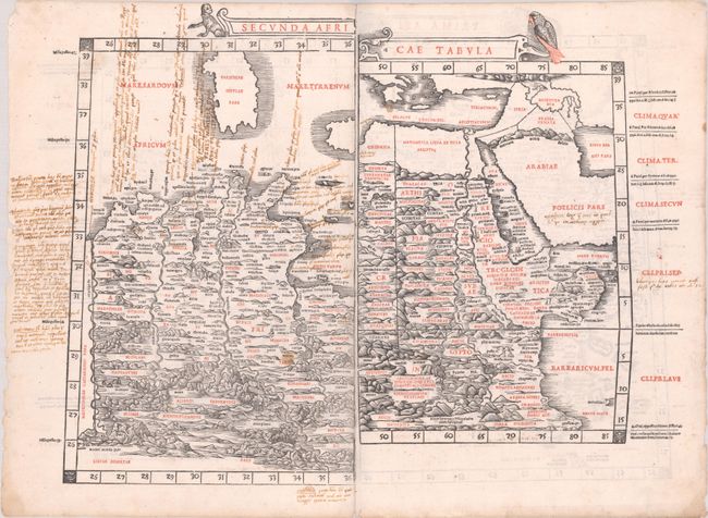
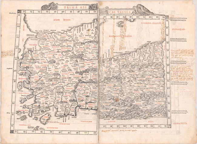
This is an extremely rare uncut sheet from the 1511 edition of Ptolemy's Geographia, showing portions from four different maps. The atlas included 28 woodcut maps, each printed from two separate blocks. With the exception of the two world maps, they were printed in such a way that the left-hand side of each map was printed on the verso of the right-hand side of the preceding map. Thus the complete maps from this atlas that are sold on today's market are now joined from two sheets, with two unrelated half maps on the verso. However, this sheet appears in its original, uncut printed form, as it would have been inserted into the atlas. All Sylvanus maps are very rare in today's market, but finding an uncut sheet like this is exceedingly so. This is an incredible find for any collector interested in Ptolemaic atlases or early printing.
On one side of this sheet is the western half of Secunda Africae Tabula, which shows part of Sardinia and the Algerian-Tunisian coast, along with the eastern half of Quarta Africae Tabula, which spans Egypt and the Arabian Peninsula. The other side features the western half of Prima Asiae Tabula, which depicts western Turkey, and the eastern half of Prima Africae Tabula, which shows part of Algeria. On each map, there are undulating mountains, bold rivers, and numerous ancient place names. The titles are flanked by a monkey, birds, and a horn. This example has extensive old manuscript commentary in Greek.
An extremely early example of 16th century Venetian cartography, the 1511 Latin edition of Ptolemy was the first printed in Venice, by Jacobus Pentius de Leucho, and was the first atlas to use two-color woodblock printing. The maps were printed in black with place names and headings printed in red ink by means of type set into the woodblock and applied with a second strike of the plate. The text was based on a Latin translation by Jacobus Angelus, with revised maps by Bernardus Sylvanus. Little is known of Sylvanus, a native of Southern Italy, although he is believed to have been a monk. Realizing that Ptolemy's maps were outdated, Sylvanus set out to update them with modern information, often from contemporary manuscript sources. The resulting effect was an unusual hybrid of classical and modern information. Sylvanus also introduced a new "modern" world map, depicted for the first time in a distinctive cordiform (heart-shaped) projection, which was adopted by several later cartographers and used for a number of important 16th century maps.
References: cf. Mickwitz & Miekkavaara #204-12; 13; 15; & 16.
Condition: B+
There are a few light stains, small centerfold separations and tiny areas of paper loss along the lower centerfold (no image loss), and manuscript ink notations throughout.