Subject: Hong Kong, China
Period: 1874 (dated)
Publication: Les Missions Catholiques
Color: Black & White
Size:
11.9 x 9.9 inches
30.2 x 25.1 cm
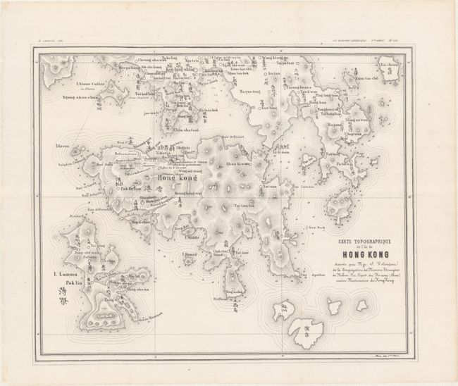
This scarce map of Hong Kong and the surrounding islands was drawn by Italian Jesuit Simeone Volonteri during his 10-year residence in the region. It is a reduced version of part of his 1866 Map of the San-On District (33.6 x 42.2"), which he compiled with his own surveys over a 4-year period from 1861-65. The 1866 map is considered the first bilingual map of the region and this 1874 edition focused on Hong Kong is likely the second. The two maps together served as the primary cartographic resource for this region until official surveys were completed in 1901. Volonteri's maps were truly remarkable accomplishments as he compiled them without formal approval by the Chinese government (an offense punishable by death) and managed to navigate the rugged terrain without a guide or outside assistance. The resulting maps provided a completely new understanding of the area with terrain depicted throughout, the elevation of several mountain peaks noted, and even soundings reported in the waters along the coastlines. Furthermore, Volonteri noted places of cultural importance on Hong Kong Island including churches, missions, monastery, protestant cathedral, reform school, and more. This map was published by Stab. Fratelli Tensi in the January 2, 1874 issue of Les Missions Catholiques. We found only one past auction record for this map and four dealer listings in the last 30 years.
References:
Condition: A
On a bright sheet that has been backed with Japanese tissue.