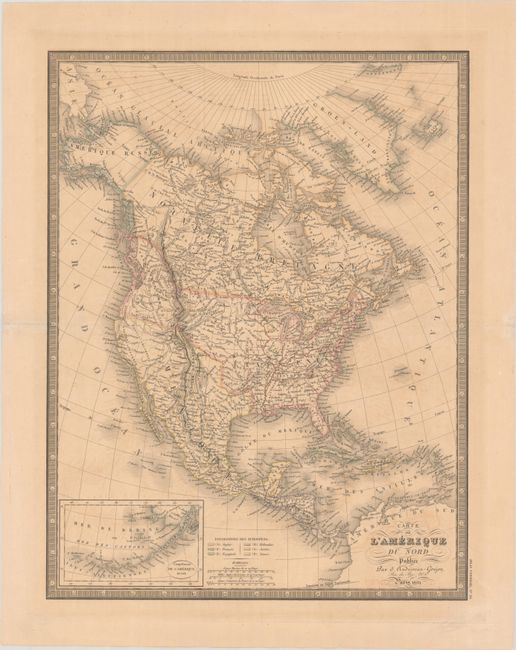
Subject: North America
Period: 1832 (dated)
Publication: Atlas Universel
Color: Hand Color
Size:
15.2 x 19.8 inches
38.6 x 50.3 cm
The United States and Great Britain established in 1818 joint claim over the Oregon Territory - the region north of Spanish controlled Upper California up to the southern boundary of Russia's Alaska Territory at North latitude 54°40'. By the late 1830's this arrangement was beginning to fall apart.
In the 1840's the expansionist Democrats, including their 1844 presidential candidate, James Polk, claimed the entire region for the United States. Their expansionist desires were expressed by Polk's famous campaign slogan, "Fifty-four Forty or Fight!" The slogan also became a rally cry for Americans desiring to settle the territory. Following Polk's election, the dispute was resolved by the 1846 Treaty of Oregon, which struck a compromise that fixed the U.S./Canadian boundary at 49º North.
This 19th-century French atlas map of the continent shows the United States in an evolving configuration. The boundary between the United States and Canada reflects the United States claims in the disputed Oregon Territory, with the border drawn along the 54th parallel. Mexico still controls Texas, the Southwest, and California. In the Great Basin, conjectural rivers flow from L. Teguayo and L. Timpanagos through Partie Inconnue and into the Pacific. Alaska is named Amerique Russe. The map shows good detail of settlements, rivers, and the locations of Indian tribes. Missouri is shown as both a state and a vast territory. To the west of Michigan Territory is Terre. du Nord Ouest, which consists of present-day Wisconsin, Michigan's Upper Peninsula, and part of Minnesota. At lower left is an inset of the Aleutian Islands and Bering Sea. Colonial possessions are indicated by color coding. The map is surrounded by a keyboard-style border. From an early edition of Andriveau-Goujon's atlas.
References:
Condition: B+
Contemporary outline color on a lightly toned sheet with minor offsetting. Tears in the blank margins have been closed on verso with archival materials.