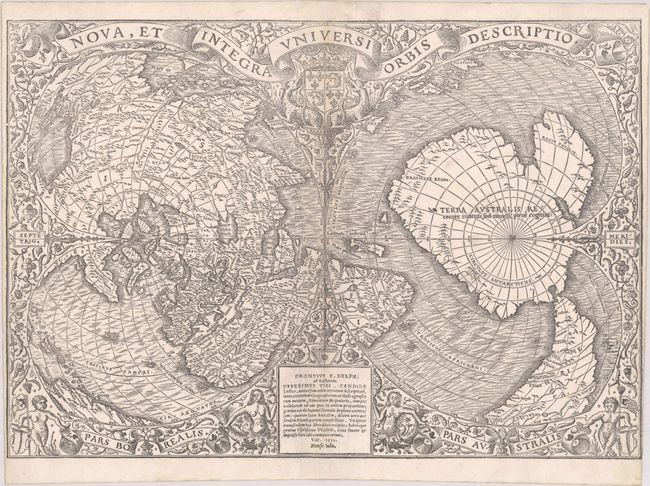
Subject: World
Period: 1531 (dated)
Publication: Novus Orbis Regionum
Color: Black & White
Size:
16.6 x 11.5 inches
42.2 x 29.2 cm
This stunning map was prepared by French cartographer Oronce Fine in 1531 for the 1532 Paris edition of Johann Huttich and Simon Grynaeus' Novus Orbis Regionum. The work, which was a compilation of accounts of voyages and discoveries, was first published in Basel in 1532 with an oval world map by Sebastian Munster and Hans Holbein. The oval world map was replaced by this double-cordiform world map in the 1532 Paris edition, which was printed by Christian Wechel. The plate was used by several different publishers for their works, including Glareanus' De Geographia in 1536 and Pomponius Mela's De Orbis Situ in 1540, which was also printed by Christian Wechel. The map went through six different states for the various publications, with changes to the imprint and date in the cartouche at bottom. This example is the rare first state bearing the imprint of Oronce Fine (Orontius F. Delph.) with the date 1531 at bottom center.
The double-cordiform projection is constructed of two heart-shaped forms, each centered on one of the poles. The right-hand cordum is centered on the South Pole and is mostly filled with Terra Australis, which is noted as being 'recently discovered but not yet explored.' The massive size of the great southern continent was assumed to balance the landmasses in the northern hemisphere, thereby enabling the earth to maintain equilibrium on its spinning axis. South America extends down to Terra Australis with the adjacent waters labeled Mare Magellanicum, which is the first reference to Magellan's circumnavigation around the world to appear on a printed map. Although an R. Brazil appears in South America, Brasielie Regio is placed along the Indian Ocean side of Terra Australis, which was likely misplaced due to a misinterpretation of several confusing accounts of Brazil being located across the waters from Africa.
The cartography of the left-hand cordum becomes even more convoluted. Here, despite knowledge of Magellan's voyage, Oronce Fine continues the myth that Asia is connected to the Americas. Northeastern Asia (essentially Russia) is connected to Labrador, which is labeled Baccalar. Further south in eastern Asia (at top left on the map), the nomenclature between Asian places and Central American places become interspersed. Central and South America are continued at bottom left, with several Caribbean islands noted, including Jamaica, Hispaniola, Puerto Rico (Borique), Dominica, and Grenada.
The map is surrounded by a delicate floral motif with the title presented in a ribbon banner at top above the arms of the Dauphin of France, a pair of mermaids flanking the cartouche at bottom, and cherubs holding a coat of arms and a flag in the bottom corners.
References: Nordenskiold (Facsimile Atlas) p. 90 & 106, plate XLI (2); Shirley #66; Suarez (Shedding the Veil) #19.
Condition: A
A sharp impression on a bright sheet with narrow side margins, as issued. There are professional repairs to short centerfold separations at top and bottom and a couple of tiny tears along the edges of the sheet. There are old creases adjacent to the centerfold at bottom that have been pressed flat, and a 1 cm separation along the right-hand fold just above "DELPH" in the cartouche at bottom has also been professionally repaired.