Subject: Colonial New England United States
Period: 1776 (circa)
Publication:
Color: Hand Color
Size:
20.8 x 25.4 inches
52.8 x 64.5 cm
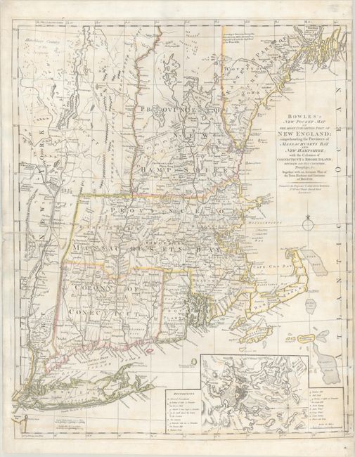
This is the fourth state of Bowles' one-sheet issue of Jefferys' influential 4-sheet map of New England. Jefferys' map was first published in 1755 at the beginning of the French and Indian War, and became the most influential map of the region for the next several decades. The map was compiled by Bradock Mead (alias John Green) from influential contemporary sources. This map closely follows the second edition of Jefferys' map (1759), although the inset of Fort Frederik is eliminated, and Bowles created a more detailed, updated inset of Boston Harbor. The inset of Boston was newly added for the third state of the map and depicts Bunker Hill and the locations of entrenchments, batteries, and redoubts. Bowles' edition shows villages, towns, forts, roads, counties, watershed, mountains and topography, and information along the coast, including islands and bays. Maine is noted as "Eastern Part of Massachusets," and Vermont is still a part of New York. This fascinating map presented up-to-date information on the region for its time, including forts, such as Fort Hunter and Fort Ticonderoga, and a reference to Sir William Johnson north of Albany. In northern New Hampshire is a "double line of towns for a frontier against the Indians."
Bowles' map was first published circa 1765, however the fourth state of this map is one of the most interesting, as it includes numerous updates related to the beginning of the Revolutionary War. In addition, the title was moved from the upper left corner to the Atlantic Ocean, allowing the geography to be extended west of Lake Champlain and Lake George, where the "Hereditary Country of the Iroquois" are noted. Also, Dartmouth College is shown for the first time on the fourth state. Each state of this map serves as an important record of the evolution of state borders, roads, and the seat of war.
Bowles' one-sheet issue is actually much rarer than Jefferys' 4-sheet map, and this is only the third example that has been listed with OWA.
References: Sellers & Van Ee #812; Stevens & Tree (MCC-39) #32(d).
Condition: B+
A nice impression on a sheet with a Strasbourg Lily watermark. The sheet has been professionally cleaned, deacidified, and backed with archival tissue, repairing separations along the centerfold at right and left and a tear parallel to the centerfold. Some light, scattered staining remains on the sheet, and there is minor cockling of the paper at top. Trimmed close to the neatline at right, apparently as issued.


