Subject: Honolulu, Hawaii
Period: 1942 (dated)
Publication:
Color: Black & White
Size:
33.7 x 20.5 inches
85.6 x 52.1 cm
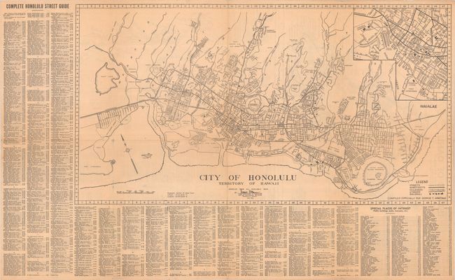
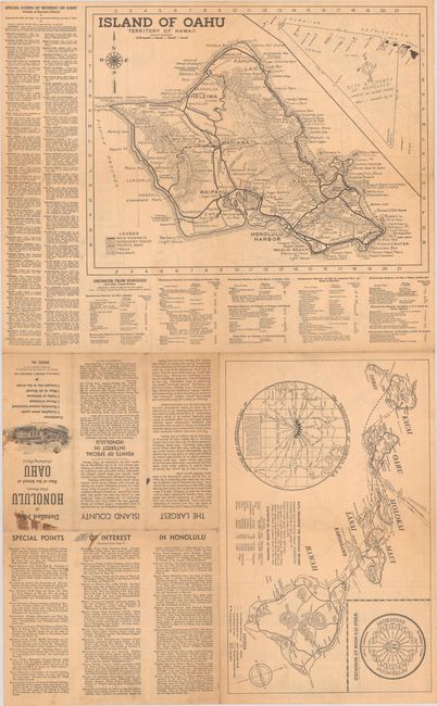
Published in the aftermath of the attack on Pearl Harbor, this brochure features three maps: City of Honolulu Territory of Hawaii (28.3 x 15.1"); Island of Oahu Territory of Hawaii (16.6 x 13.0"); and a general map of the territory (16.1 x 9.9"). The detailed map of Honolulu shows streets, main streets, railroads, streams, and buildings, with an inset zooming in on Honolulu Harbor. The map is surrounded by a complete street guide and an alphabetical listing of places of interest. The Oahu map features nice topographical detail as well as main highways, secondary and private roads, trails, and railways. An inset at top right demonstrates that Honolulu is the largest city in the United States, showing its jurisdiction extending south to Palmyra Island and west almost to Midway. Surrounding the map are a list of points of interest on the island and a listing of distances from Honolulu. The general map identifies lava flows and various transportation routes from island to island. There is also a clock comparing noon in Honolulu to other major cities and a map emphasizing Hawaii as "the Crossroads of the Pacific." Published by George T. Armitage and printed by the Honolulu Star-Bulletin.
References:
Condition: B+
Issued folding with light toning and minor loss at a couple of fold junctions. There is staining on brochure cover and informational text, not impacting any of the map images.