Current Auction
Lot 28
Current Auction

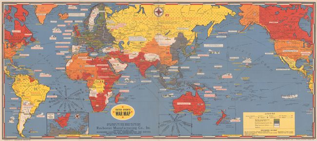
"Dated Events War Map [14th Edition]", Turner, Stanley
Subject: World, World War II

Period: 1944 (dated)

Publication:

Color: Printed Color

Size:
38.6 x 16.9 inches
98 x 42.9 cm
Download High Resolution Image
(or just click on image to launch the Zoom viewer)

This striking, colorful WWII progress map chronicles major events in the war up to January 1944, with the most recent events being "Roosevelt-Stalin-Churchill Tehran Conference 'Smash Germany' Nov. 28 to Dec. 1-43" and "Mass attack air war against nazis JAN-44." There are several battleships in the oceans, and Japanese planes are shown swarming above Hawaii to mark the attack on Pearl Harbor. An inset at bottom left covers "North Sea and Channel Ports." The legend identifies the naval bases of the various countries involved in the effort and uses color-coding to indicate which countries are part of the Axis (green), conquered by the Axis (gray), Vichy France and colonies (blue and white), and neutral (white). The map features an advertisement by Rochester Manufacturing Co., Inc. encouraging viewers to "help erase the gray blots on this map by buying U.S. War Bonds and Stamps." A compass rose-like diagram at left shows the distance and direction of various European cities relative to Berlin. The bottom margin lists this as the 14th Edition in this popular series. Produced by C.C. Petersen Advertising in Toronto.

For a brief article on the Turner maps, click here.

References: cf. Rumsey #10065.

Condition: B+

A bright example issued folding with a couple short fold separations and minor wear along a few fold lines.

Estimate: $140 - $170

Sold for: $160

Closed on 11/20/2024

Closed