Subject: Southeastern Pennsylvania
Period: 1822 (dated)
Publication:
Color: Hand Color
Size:
21.8 x 17.3 inches
55.4 x 43.9 cm
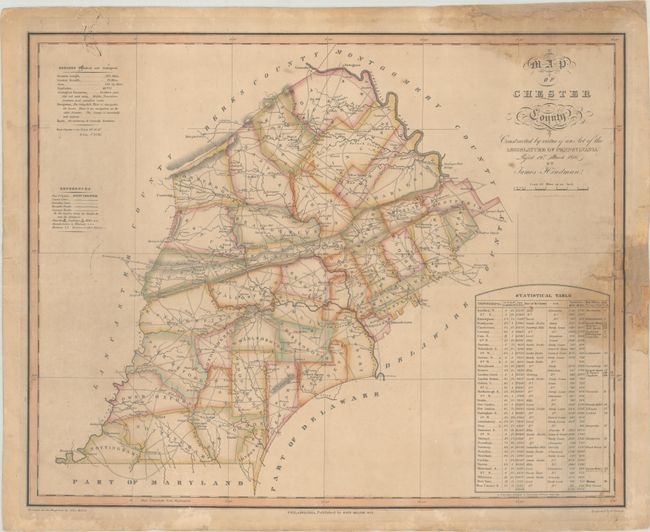
This rare map of Chester County was drawn by James Hindman and engraved by Benjamin Tanner for inclusion in John Melish’s large map of the Pennsylvania. The map, drawn at a scale of 2.5 miles per inch, is divided into townships and presents remarkable detail for its time, with a key at left identifying turnpike roads, common roads, churches, mills, manufactories, minerals, taverns, and more. General statistics for the county are summarized at top left while a detailed statistical table at lower right lists all the townships along with their size, topographical description, soil type, population growth from 1810-20, and more.
Melish was a strong believer in state-financed cartography, asserting that individuals would not have the necessary resources or finances to properly maintain state maps, and that state maps, therefore should be the official responsibility of the state. His comments were transmitted to influential legislators in Pennsylvania, who passed an act in 1816 "Directing the Formation of a Map of Pennsylvania" and subsequently hired Melish to publish the map. The Surveyor General contracted with deputy surveyors (Hindman in this case) to provide accurate maps of each county, which were then collected and sent to Melish for compilation into the state map. The state map was finally ready for publication in 1822 after Melish and his assistants spent six years compiling the map, and Tanner spent another fifteen months engraving the plates.
These early Melish Pennsylvania county maps are scarce on the market. We found only two past sales records of the Chester map (2005 and 2013) and three other examples of other Melish Pennsylvania county maps in the last 30 years.
References:
Condition: B
Contemporary outline color on a lightly toned sheet with dampstains at right and upper right along with old stray ink marks at upper left. Backed on a heavy archival sheet to reinforce and repair a small chip in the image at right with a tiny amount of border in facsimile, as well as some edge chips in the blank margins.


