Subject: Portobelo, Panama
Period: 1740-57 (published)
Publication:
Color:
A. A Plan of Porto Bello, by Anonymous, from London Magazine, published 1740, black & white (7.0 x 4.0"). This small woodcut plan shows the harbor and forts of Portobelo during the English attack led by Vice Admiral Edward Vernon. The Battle of Porto Bello (or Portobelo), was a conflict between Britain and Spain during the War of Jenkins' Ear, part of the War of the Austrian Succession. Portobelo was a strategic Spanish transfer point for gold and silver coming from South America. After taking part in a failed attempt to capture a fully laden Spanish treasure ship departing from Portobelo in 1727, Vice Admiral Edward Vernon made claims that he could capture the historic port with just six ships. In November 1739, Vernon organized a squadron of six ships to capture the settlement. Due to strong easterly winds, Vernon was initially forced to focus his efforts on the harbor fort. The British caught the Spanish off guard and quickly gained control, forcing the Spanish to surrender the fort. Subsequently, Vernon shifted his efforts to the town of Portobelo, resulting in Spanish surrender of the port. The capture of Portobelo was seen as a big triumph in Britain and America, and the names Portobelo and Vernon were used in commemoration (including Portobelo Road in London, the Portobelo district of Edinburgh, and Mount Vernon in Virginia, the home of George Washington). The British occupied Portobelo for only three weeks, destroying the fortress and key buildings before withdrawing. On verso is a letter of congratulations for the victory from the mayor, aldermen, and commons of the city of London to the king, with the king's response. Reference: Jolly #LOND-1. Condition: Faint showthrough of text on verso.
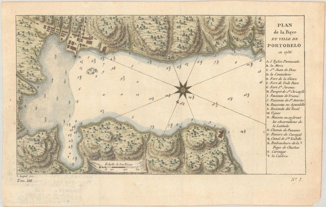
B. Plan de la Baye et Ville de Portobelo en 1736, by Jacques Nicolas Bellin, from Histoire Generale des Voiages ... Tome Cinquantieme, published 1757, hand color (9.2 x 5.1"). This is a slightly reduced version of Bellin's chart of Portobelo Bay. It shows Portobelo, the important Spanish port city on the northern coast of Panama. Numerous soundings are located, and a key at right identifies important locations. It is based on the plan by Antonio de Ulloa and Jorge Juan, first published in 1752. Not listed in Kapp's carto-bibliography of Panama. Engraved by Elisabeth Haussard, best known for her work for the Robert de Vaugondy family. Condition: On watermarked paper with a tiny rust spot.
References:
Condition: A
See description above.


