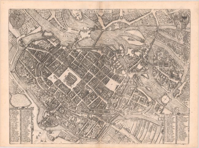
Subject: Wroclaw (Breslau), Poland
Period: 1587 (dated)
Publication: Civitates Orbis Terrarum, Vol. IV
Color: Black & White
Size:
19.3 x 14.4 inches
49 x 36.6 cm
Braun & Hogenberg's Civitates Orbis Terrarum or "Cities of the World" was published between 1572 and 1617. Within the six volumes, 531 towns and cities were depicted on 363 plates, providing the reader with the pleasures of travel without the attendant discomforts. Braun wrote in the preface to the third book, "What could be more pleasant than, in one's own home far from all danger, to gaze in these books at the universal form of the earth . . . adorned with the splendor of cities and fortresses and, by looking at pictures and reading the texts accompanying them, to acquire knowledge which could scarcely be had but by long and difficult journeys?" Braun and Hogenberg incorporated an astonishing wealth of information into each scene beyond the city layout and important buildings. The plates provide an impression of the economy and prominent occupations, and illustrate local costumes, manners and customs.
Viewed from the southwest, this bird's-eye plan of Wroclaw shows the city surrounded by water, with the River Oder at top. Two large market squares dominate the city center, while Cathedral Island is shown at far right. Two numbered keys identify more than 90 locations. Dated 1587, but published in either 1588 or 1594. Latin text on verso.
References: Fussel, pp. 322-25; Van der Krogt (Vol. IV) #2500.
Condition: A
A nice impression with a small hole near centerfold at bottom, minor toning and offsetting along centerfold, and a short centerfold separation in the top blank margin that has been archivally repaired