Subject: Northeastern United States & Canada
Period: 1815 (published)
Publication:
Color: Hand Color
Size:
24.3 x 30 inches
61.7 x 76.2 cm
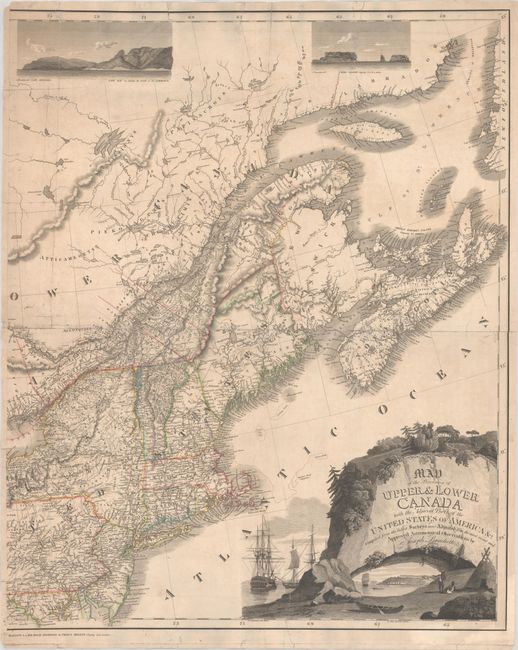
This the eastern sheet of Bouchette's rare two-sheet map of the provinces of Upper and Lower Canada and part of the Eastern Seaboard. It depicts the region from the Strait of Belle Isle south to Washington, D.C. There is excellent detail of towns and cities, rivers, lakes, roads, and district boundary lines. County formation is detailed in Nova Scotia, Pennsylvania, and New York. Much of the land along the United States-Canada border is divided into square plots, some numbered and some with the names of newly formed townships. In New York, the Totten and Crossfield Purchase and an Old Military Tract are noted in the Adirondacks. A vast Bingham's Purchase is shown in the District of Maine, referring to the tracts of land purchased by Philadelphia banker William Bingham. Quebec City, Montreal, and Kingston are identified and shown in nice detail. There are two coastal views at top (both credited to Bouchette) showing Cape Anguille and Cape Ray (left) and the Bird Islands (right). The massive decorative title cartouche at bottom right features landscape scenes, Indigenous figures with shelter and canoe, and vignettes of the HMS St. Lawrence, a ship that served on Lake Ontario during the War of 1812, and a view on Lake Ontario. The map is dedicated on its western sheet to George Augustus Frederick, Prince of Wales, Duke of Cornwall, and Prince Regent of the United Kingdom of Great Britain and Ireland. Engraved by J. Walker. The full publisher's imprint, only half of which is visible here, reads "Published, as the Act Directs, Augst. 12th, 1815, by W. Faden, Geographer to His Majesty & to His Royal Highness the Prince Regent, Charing Cross, London."
The map accompanied A Topographical Description of the Province of Lower Canada, with Remarks Upon Upper Canada... (1815), as well as the concurrent French edition Description Topographique de la Province du Bas Canada..., both published by William Faden. This atlas also included a 10-sheet topographical map of Lower Canada, drawn on a scale of 24 miles to the inch, which is described by Rumsey as "the equal (or perhaps the superior) of any of the contemporary maps that we have seen."
In 1804, Joseph Bouchette (1774 - 1841) was officially appointed Surveyor General of British America. Beginning in 1807, he began collecting data for a new map of Lower Canada. During the War of 1812, Bouchette ran reconnaissance missions and commanded the Quebec Volunteers. After the war service, he completed his map of Lower Canada and the accompanying topographical dictionary, an effort that earned him a medal from the Society for the Encouragement of Arts, Manufactures, and Commerce in London. Bouchette's map of Upper and Lower Canada was updated by his son in 1831. The Bouchettes intended this updated edition to encourage immigration to Upper Canada and to unite Upper and Lower Canada as a single province, which was in line with Britain's desires but not those of the French Canadians.
We have only seen two examples of Bouchette's complete map on the market in the last 20 years, in addition to a few institutional copies in the Library and Archives Canada, the Boston Public Library, and the David Rumsey Historical Map Collection.
References: Rumsey #4431.016; Sabin #6849.
Condition: B
A sharp impression with contemporary outline color on a sheet with an "Edmeads & Co 1811" watermark. There are separations along the centerfold and some edge tears that extend between 2-5" into map image, all of which have been closed on verso with mostly archival materials. A small puncture in an unengraved area at top has been repaired with nonarchival tape. There are a couple vertical extraneous creases and minor soiling.