Subject: Colonial Great Lakes
Period: 1757 (dated)
Publication: Allgemeine Historie des Reisen zu Wasser und Lande
Color: Black & White
Size:
11.3 x 7.5 inches
28.7 x 19.1 cm
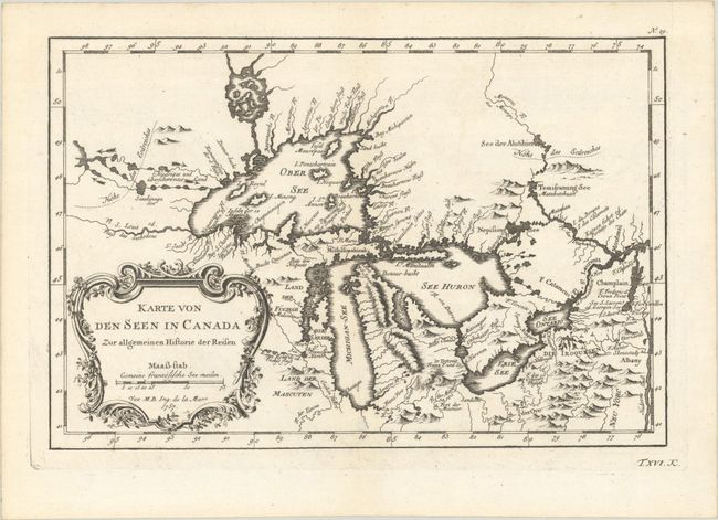
This is an excellent German edition French & Indian War period map depicting the five Great Lakes. While very similar to Bellin's prototype map that was published in Charlevoix’s Histoire et Description Generale de la Nouvelle France in 1744, it has been updated with information from Bellin's map of 1755. Lakes Erie and Ontario are more accurately defined and the spurious islands in Lake Huron have been eliminated. However, several large, bogus islands still remain in Lake Superior, including I. Minong (called I. Philippeaux on some issues) and I. Pontchartrain. The Michigan peninsula is still misshapen with a massive mountain range down its center. Numerous forts are located: S. Jgnace, Niagara, des Miamis, and Toronto to mention a few. The ornate rococo title cartouche is draped with ivy.
References: Kershaw #954; cf. Portinaro & Knirsch #CXXVI; cf. Tooley (MCC-96) #871.
Condition: A
A crisp impression on a bright sheet with one small area of paper weakness along the lower centerfold.