Subject: World
Period: 1702 (circa)
Publication: Nouvelle Metode pour Aprende Facilement et sans Maitre la Geografie
Color: Hand Color
Size:
25.6 x 17 inches
65 x 43.2 cm
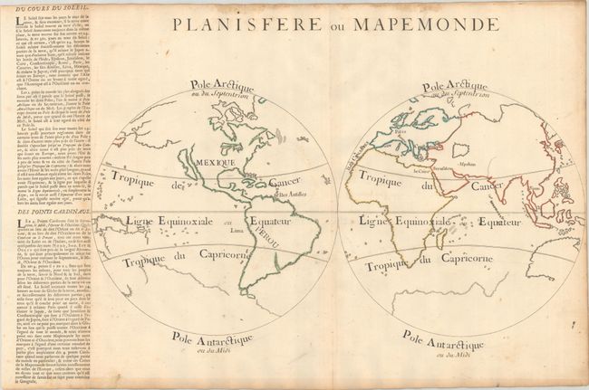
This simple double-hemisphere map of the world is presented only with the outlines of the continents and islands. Almost all nomenclature has been omitted, with the exception of a few seemingly random cities, countries and islands. These locations, along with the climactic zones and the poles, have been added in manuscript, some using stencils. The map was created by Louis Dangeau and used multiple times in his geography book to depict various geographical terms, with different nomenclature added to each version. The map depicts California as an island and has only a partial outline of Australia and New Guinea. Several conjectural lands still appear, including a large southern continent and a partially delineated land to the east of Japan, stretching across the North Pacific. A column of explanatory text regarding the sun and cardinal directions has been pasted onto the left edge of the sheet, adjacent to the map. A very uncommon map.
References: Rumsey #3658.005; Shirley #588.
Condition: B+
Contemporary outline color, issued folding on a sheet with a bunch of grapes medallion watermark. There is moderate toning and foxing along the edges of the sheet, with a few spots of foxing and light soiling in the image.