Subject: Colonial Mid-Atlantic United States
Period: 1681 (published)
Publication: Geographiae Universalis
Color: Hand Color
Size:
4.8 x 3.9 inches
12.2 x 9.9 cm
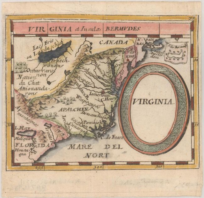
This charming miniature map covers the coastline from Long Island to the May R. in South Carolina and inland to Lake Erie and the mythical Lake May. It depicts the defunct Swedish colony, the Dutch colony of New York (Nouvel Amsterdam), and the French claim to Florida. The colony of Virginia is shown with Jamestown and the Indian city of Orapaks. In the west is a large Lac Erie ou Lac du Chat (named for the panther like fierceness of its Indian inhabitants). Several Native Indian tribes are named, including Iroquois. A tiny inset map of the island of Bermuda is included above the bold oval title cartouche. An alternate title Virginia et Insulae Bermudes appears across the top. This is the second state with page number 75 at top right.
Pierre Duval was Nicolas Sanson's nephew and pupil. He published a wide range of atlases and individual maps including a fine miniature world geography with many of the maps based on Sanson. This map is from the rare German edition of Duval's world geography. The maps were probably engraved by Sigismund G. Hipschman (as his signature appears on the title page and the world map) and have Latin titles rather than the original French. The maps are often attributed to Johann C. Beer, who translated the work into German, and Johann Hoffman, who published Geographiae Universalis.
References: Burden #502; Cumming (SE) #85; King (2nd ed) pp. 144-145.
Condition: A
A dark impression on a bright sheet with narrow side margins and minor creasing.