Subject: World
Period: 1750 (circa)
Publication: Voyage Autour du Monde
Color: Black & White
Size:
15.8 x 8.9 inches
40.1 x 22.6 cm
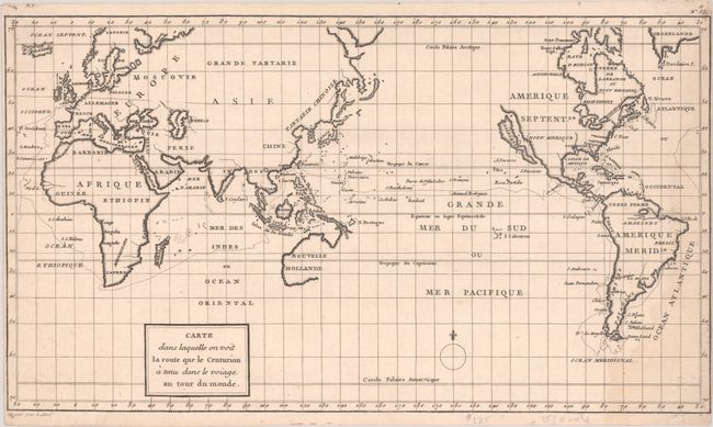
This map of Anson's voyage around the world is from a French edition. It was engraved by Lattre and is identical to the English edition "A Chart Shewing the Track of the Centurion Round the World…" except for the French place names and title. Details are primarily confined to the coastlines, with mostly blank interiors save for large rivers, lakes, seas and important cities. California is depicted as an island, and is a late depiction of this cartographic error. Only the western half of Australia is delineated and is connected to New Guinea, and there is no mention of New Zealand.
This map accompanied an account of Commodore Anson's expedition to the South Seas to harass the Spanish bases but, more importantly, plunder their shipping. From a military viewpoint the expedition was a disaster: back-stabbing in the Admiralty meant that Anson was equipped with poor ships and received a regiment of Chelsea Pensioners rather than the promised Marines. One had served at the Battle of the Boyne sixty years earlier! Half had deserted before they reached the docks at Portsmouth. An atrocious voyage meant that the fleet arrived in the Pacific in very poor shape, but a stroke of luck presented them with a Spanish galleon laden with silver. On their return to London, thirty-two wagons were needed to transfer it to the Tower of London.
References: cf. Shirley (BL Atlases) G.ANS-2a.
Condition: B+
A dark impression on watermarked paper with a light dampstain at right.