Subject: World
Period: 1755 (circa)
Publication:
Color: Hand Color
Size:
28.8 x 20.6 inches
73.2 x 52.3 cm
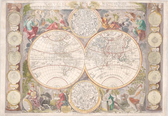
This rare, separately-issued map includes fascinating geographical misconceptions and a superb decorative surround. Of particular interest is the cartography of northwest North America, which carries forward the myth of a Northwest Passage. The mythical Sea of the West (Mer de l'Ouest) appears just north of Cape Mendocino, with conjectural dashed and dotted lines connecting it to Hudson Bay. Further north is another possible passageway via Lac de Valasko and Detroit de Lancastre. Alaska is still completely conjectural, labeled as Presqu'isle du Nord Ouest with a note that the land was sighted by the Russians in 1741. Only a few cities are noted, including Charleston, Quebec, and a couple of forts.
The conjectural cartography continues in the South Pacific, with Australia connected to both Tasmania and New Guinea, and only the western portion of New Zealand is delineated A few sightings of land are noted in the Antarctic Ocean.
The decorative elements surrounding the hemispheres are quite elaborate, with celestial spheres in the cusps, and columns flanking the sides of the map supporting 10 astronomical diagrams of the sun, moon and planetary systems. Above the map are allegorical figures representing the sciences, while at bottom are featuring female figures representing the four continents, each accompanied by a note outlining the various countries and regions within each continent. Each continent is escorted by an animal: a horse for Europe, a camel for Asia, an elephant for Africa, and an alligator for the Americas.
The map is dedicated to Bertrand Rene Pallu, who was the Intendant of Lyon from 1739-50. Engraved by Delamonce and sold by Daudet in Lyon. Nicolas Bailleul was the youngest son of Gaspard Bailleul, a prominent geographer and publisher in Paris. The family frequently worked with the house of Daudet to publish their works. Only a few maps have been attributed to Nicolas Bailleul, including this map of the world, and continental maps of the Americas and Africa. Bailleul's maps rarely appear on the market. We have only found two examples of this world map in institutions, and a handful of examples that have been offered on the market in the last 30 years.
References: McGuirk #50.
Condition: B+
A nice impression on a bright sheet with the watermarks of "Montgolfier 327" and a large house. There are professional repairs to a few tiny worm holes and some short tears along the edges of the sheet, most of which enter less than 1" into the image, and one entering 3" into the image by the female representation of Africa.