Subject: New York City, New York
Period: 1868 (published)
Publication:
Color: Printed Color
Size:
23.5 x 8.6 inches
59.7 x 21.8 cm
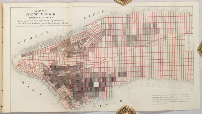
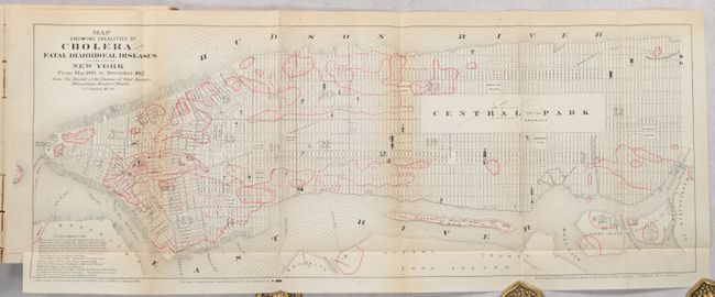
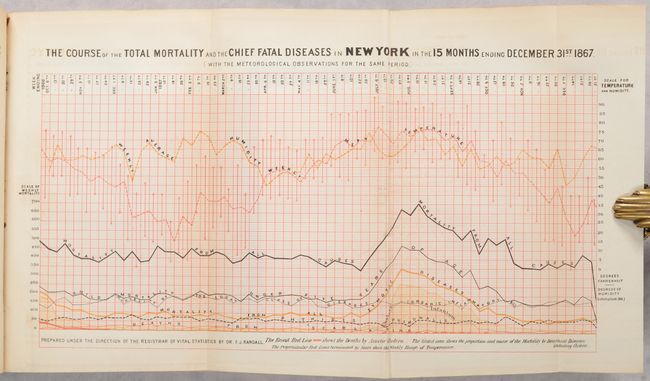
Published by the Metropolitan Board of Health of the State of New York, this thematic map of southern Manhattan documents the last cholera epidemic in New York City in 1866-67. Similar to the Snow map of London in 1854, it was drawn based on an examination of “the history and local circumstances of every fatal case of cholera” located here by dots on the map. The map identifies the “cholera fields,” assumed to be the sources of cholera where “certain conditions of putrescence in the earth, the atmosphere or potable water are present.” The city used chemical antiseptics to disinfect the affected areas. The text extensively details the struggle to understand the cause and means to prevent the deadly disease. The establishment and successful operation of the Board of Health greatly improved sanitary conditions in the city and prevented new outbreaks. A second map, Map of New York South of 63rd Street Showing the Relative Density of Population in the Different Sections (8.3 x 13") is accompanied by explanatory text pleading for more open space in the crowded tenement sections: “It will be observed, by mere inspection of this map, how little provision has been made for the ventilation of the most thickly-crowded districts and narrow streets, and an almost entire absence of public squares.” 480 pages with folding tables, maps and an 8-page index. Octavo, disbound.
References:
Condition: B+
The large folding map has a bit of offsetting and light toning along the sheet edges. The smaller map is trimmed to just inside the bottom border by the binder. Text and other plates have a hint of light toning. Text block is fairly loose. Disbound.