Subject: Gulf of Mexico & Caribbean
Period: 1730 (circa)
Publication:
Color: Hand Color
Size:
39.8 x 23.1 inches
101.1 x 58.7 cm
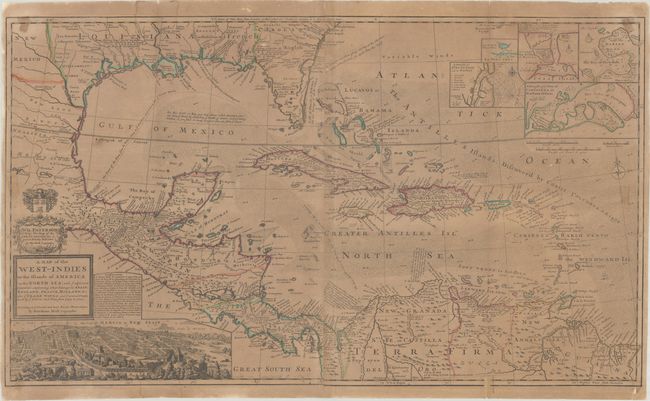
This large and incredible chart, published during an era of English piracy and privateering in the region, is filled with so much information, notes, place names, and interesting configurations that it almost defies description. The map extends from the Rio Grande east to the Bahamas and the Caribbean, and from Charles Town south to northern South America. The rich silver mining area of Caouila (Coahuila) is shown near the bounds of New Mexico. Louisiana occupies the entire Gulf Coast and is noted as being in Possession of ye French. Florida is depicted in triangular form and is called the region of Lakes, Morasse's and Broken Land. Georgia extends west to the Apalaxy River and is labeled Carolina - English. Texas is not named, but the region is labeled Quelameloueches (a possible reference to the Comanche Indians) and is a Country full of Beeves. This region extends to name New Mexico, which itself is above New Leon in northern Mexico. An interesting notation in present-day Chiapas describes the route used to transport cannons to Acapulco. Many details in the Caribbean Sea and Gulf of Mexico relate to the routes of Spanish galleons, and there are many other notes on the Trade Routes to Spain. The lines of longitude show the number of hours difference from London. A large inset view of Mexico City fills the left quadrant of the map and five smaller insets detail Havana, St. Augustine, Portobello, Cartagena, and Vera Cruz. A dedication cartouche to Sir William Paterson, who died in 1719, is topped by a coat of arms. Paterson founded the Bank of England, was a prominent trader in the West Indies, and was the main proponent of the infamous Darien scheme. This edition does not include the imprints of Thomas and John Bowles at bottom center; a note at bottom reads "Sold by H. Moll and by I. King at ye Globe in ye Poultrey near Stocks Market." Printed on two sheets, joined as issued.
Herman Moll was one of Britain's most prominent cartographers of the first half of the 18th century. He emigrated from Germany and went to work as an engraver for Moses Pitt in 1678. Soon he joined one of London's most interesting social circles, which gathered at Jonathan's Coffee House and included stock speculators, scientists, archaeologists, authors, pirates, and sea-captains. From these friends, Moll gained a great deal of privileged information that he compiled into his cartographic works. Moll's success and prosperity was due in part to his social connections and political astuteness, and to his distinctive style and quality workmanship. He produced a great number of often-innovative maps, charts, globes, atlases, and geographies. His best known works are the large two-sheet maps produced for his World Described, which were also published separately.
References: Shirley (BL Atlases) T.MOLL-4b #10.
Condition: C+
A nice impression with contemporary outline color, issued folding on watermarked paper. There is moderate toning, light tape stains along the edges of the map, an extraneous crease adjacent to the centerfold, and a dampstain along the left fold at top and bottom. There are several short tears that have been repaired, including a 2" fold separation that has been partially closed with old paper on recto, and a 1.5" edge tear that is backed in archival tissue, both at bottom right.