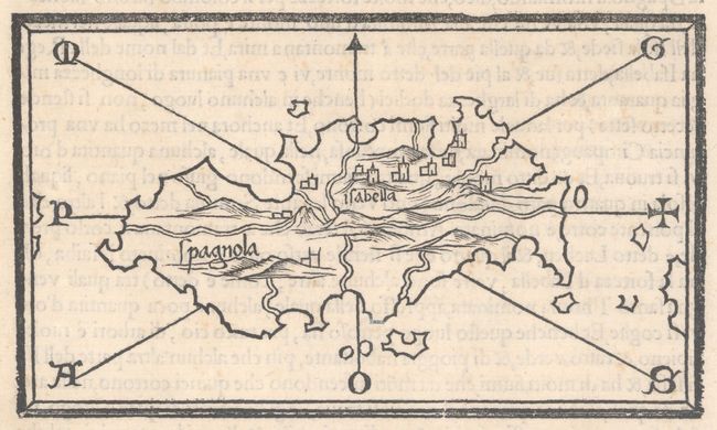
Subject: Hispaniola
Period: 1528 (circa)
Publication: Isolario de Benedetto Bordone…
Color: Black & White
Size:
5.8 x 3.4 inches
14.7 x 8.6 cm
A lovely and simple woodcut map of Hispaniola, here named as Spagnola with general topography and towns noted. Isabella, which was founded by Columbus on his second voyage to the New World, is prominently depicted. The map was published in Benedetto Bordone's Isolario (which translates as "book of islands"), the first atlas covering the entire world based on contemporary information rather than classical geography. It included 112 simple and striking maps scattered through the text, depicting islands throughout the world, with a particular emphasis on islands in the Mediterranean Sea. Bordone first published his Isolario in 1528, with further editions in 1534, 1547, and 1565. Bordone was an illuminator and wood-engraver working in Venice, when he was given permission by the Senate to print maps of Italy and the world. None of those maps have survived and his only remaining works are the maps from the Isolario. On a full sheet of Italian text (8.0 x 11.6").
References: King (2nd Ed.) pp. 48-49; Mickwitz & Miekkavaara #28-14; Shirley (BL Atlases) T-BORD-1a #15.
Condition: A
On watermarked paper with light foxing primarily confined to blank margins and a short worm track in right blank margin.