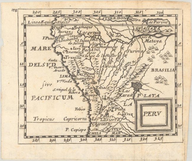
Subject: Peru & Amazon River
Period: 1670-1700 (circa)
Publication:
Color: Black & White
A. Peru, by Duval/Beer, from Geographiae Universalis…, circa 1694 (4.9 x 4.0"). Charming miniature map covering the region from the Equator to the Tropic of Capricorn. At upper right corner in Guaiana the mythical Lac Parime is shown with the golden city of Manoa on its western shore. Lac Xaraies appears as well.
Pierre Duval was Nicolas Sanson's nephew and pupil. He published a wide range of atlases and individual maps including a fine miniature world geography with many of the maps based on Sanson. This map is from the German edition of Duval's world geography. New maps were engraved by Sigismund G. Hipschman (as his signature appears on the title page and the world map) and have Latin titles rather than the original French. The maps are often attributed to Johann C. Beer, who translated the work into German. Reference: King (2nd Ed.) pp. 132-135; Shirley (BL Atlases) T.BEER-1a #14. Condition: Issued folding with a hint of foxing. (A)
B. Le Perou et le Cours de la Rivre. Amazone, by Nicolas Sanson, circa 1700 (11.0 x 8.0"). This handsome map covers the western part of the continent and the full course of the Amazon. The spurious Lac, ou Mer de Parime is prominent as is the location of the mythical city Manoa o el Dorado (City of Gold). The map is fully engraved to show topography, cities, and villages and is decorated with an attractive strapwork title cartouche. Although his imprint does not appear on this map, this map was re-engraved from Sanson's 1657 map by Antoine de Winter.
Sanson's small maps from his L'Amerique en Plusieurs Cartes..., first published in 1657 and engraved by A. Peyrounin, were copied several times by various map publishers. Johann David Zunners made copies of Sanson's maps for his German translation of Die Gantze Erd-Kugel in 1679. Johannes Ribbius and Simon de Vries published copies in 1682 and 1683, with new maps engraved by Antoine d'Winter. The plates were later sold to Francois Halma, who used them in 1699 and then again in 1705 with the titles re-engraved in Dutch. The titles on the d'Winter plates were re-engraved back into French, and then used by Nicholas Chemereau in 1715 and by Henri du Sauzet in 1738. Condition: A nice impression issued folding, now flat, with light foxing and remnants of hinge tape on verso. Margin has been trimmed close to neatline at left and top. (B+)
References:
Condition:
See description above.