Subject: Chile
Period: 1616-59 (circa)
Publication:
Color: Black & White
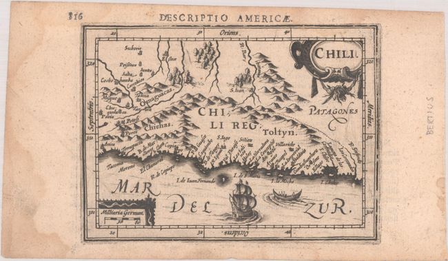
A. Chili, by Hondius/Bertius, from Tabulae Geographicae Contractae..., circa 1616 (5.2 x 3.8"). This beautifully engraved and uncommon miniature map of the Chilean coast spans from Arica south to Chiloe Island. It extends past the Andes to show portions of present-day Bolivia and Argentina. Among the several places named are Potosi, Cochabamba, Santiago, Concepcion, Valdivia, and Patagones, which is a mostly blank region in the southeastern corner of the map. A ship and canoe decorate the Mar del Zur, and the map is adorned with ornate title and distance scale cartouches. North is oriented to the left. Latin text on verso, published between 1616-18. Reference: King (2nd ed.) pp. 96-99; Van der Krogt (Vol. III) #9920:342. Condition: A dark impression with light dampstaining that is mostly confined to the sheet's edges, a printer's crease at left, and marginal soiling. (B+)
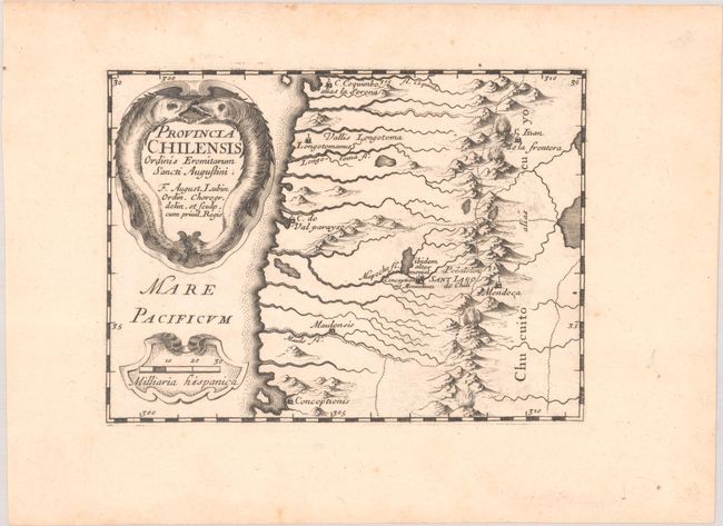
B. Provincia Chilensis Ordinis Eremitarum Sancti Augustini, by August Lubin, from Orbis Augustinianus sive Conventuum Ordinis Eremitarum..., circa 1659 (6.6 x 4.9"). This decorative miniature map of Chile was published in August Lubin's scarce atlas showing the locations of the convents of the Hermits of St. Augustine. It extends beyond the Andes into Chucuito alias Cuyo, part of today's Argentina. The map shows rivers and boldly engraved mountains and identifies the following cities: C. Coquimbo alias la Serena, Longotoma, S. Iuan de la Frontera, Valparaiso, Santiago, Mendoza, Molina, and Concepcion. The map includes a decorative title cartouche with two barracuda-like fish and a distance scale cartouche. Condition: A crisp impression with marginal foxing. (A)
References:
Condition:
See description above.