Subject: Western South America, Peru
Period: 1723-83 (circa)
Publication:
Color: Hand Color
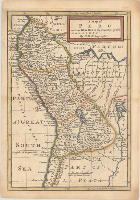
A. A Map of Peru and the West Part of the Country of the Amazones, by Herman Moll, circa 1723 (6.9 x 10.1"). Engraved in Moll's distinctive style, this map covers present-day Ecuador, Peru, Bolivia and western Brazil. The mythical lake Iarajes or Xarayes is shown at right, and the interior has a note: "This Country and its Inhabitans are very little known." Gold mines are located along the Amazon River, and The Great Road of ye Ingas is shown from Pasto in Colombia to La Plata in Peru. The map was first published in Atlas Geographicus. "Printed for Carington Bowles in London." Reference: cf. McCorkle (18th C. Geography Books) #9, Vol V [7]; cf. Shirley (BL Atlases) T.MOLL-3a #88. Condition: A nice impression on a sheet with a large medallion watermark. There is light toning and offsetting and a short archival repair along the centerfold in the right blank margin. (B+)
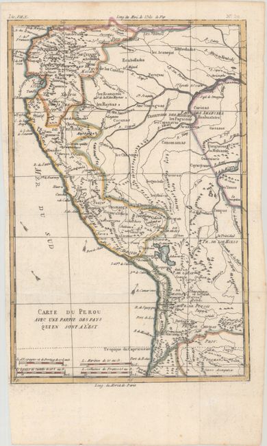
B. Carte du Perou avec une Partie des Pays Quien sont a l'Est, by Rigobert Bonne, from Atlas de Toutes les Parties Connues du Globe Terrestre, circa 1780 (8.4 x 12.7"). This attractive regional map of the western coast of South America extends from Ecuador, through Peru and present-day Bolivia, into northern Chili. There is nice detail with the locations of numerous missions and many other place names throughout. Crudely engraved arrows in the Pacific indicate the directions of the currents. Condition: Issued folding with a few minor spots and a tiny abrasion in the border at bottom. Narrow left margin. (A)
References:
Condition:
See description above.