Subject: Strait of Magellan
Period: 1780 (circa)
Publication:
Color: Black & White
Size:
19.8 x 9 inches
50.3 x 22.9 cm
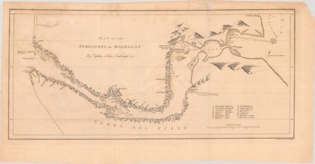
John C. Russell engraved this detailed chart based on the extremely rare and highly influential Narborough map of the Strait of Magellan. In 1670, John Narborough was the first Englishman to sail through the Strait of Magellan in both directions; thus demonstrating the falsity of the accepted wisdom that the wind and currents would prevent any eastward passage of the strait. He had been commissioned by James, Duke of York (later James II), to sail to South America to investigate potential trade possibilities. Narborough's expedition proved that a profitable trade with South America was possible, and this set the course of Britain's foreign policy for the next half century. Narborough published his journal of the voyage in An Account of Several Late Voyages… in 1694. His description of the Strait of Magellan provided the basis for British charts of the strait until the time of Captain Cook. The chart includes soundings, anchorages, and a key identifying 14 small islands, with notes on their topography and the presence of penguins. Pictorial representations of topography line the shores, and a note indicates "Savage people here of Common stature. They have boats."
References:
Condition: B
Issued folding, now flat, on a lightly toned sheet with light offsetting and some dampstaining that enters at top of map image. A couple short fold separations have been closed with archival materials on verso, and there is a short edge tear in the left blank margin and a chip in the top right corner.