Subject: Northeastern England
Period: 1693 (published)
Publication: Great Britain's Coasting Pilot...
Color: Hand Color
Size:
21.8 x 17.3 inches
55.4 x 43.9 cm
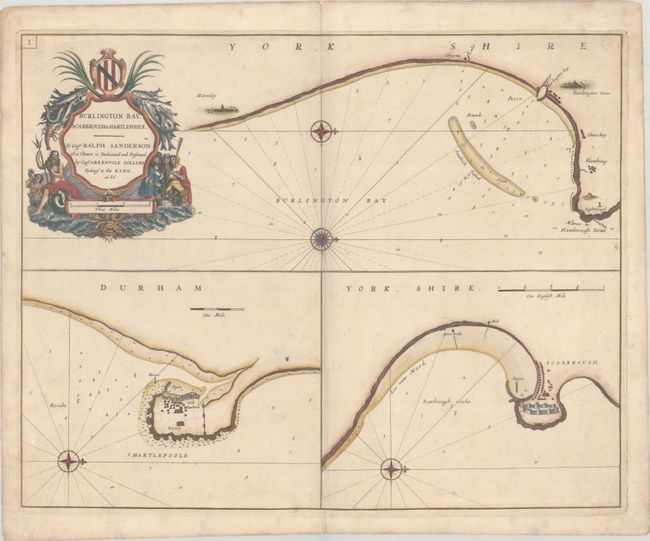
This very handsome sheet includes three charts showing the coast of Yorkshire (top), the vicinity of Hartlepool (bottom left), and the area around Scarborough (bottom right). The chart at top shows the coast along Burlington Bay, spanning from Flamborough Head, south past Burlington Towne to Hornsey (Hornsea). The Hartlepool and Scarborough charts each feature pictorial representations of piers, fortifications, and buildings. Each chart is oriented with the north to the right by a decorative compass rose with rhumblines and bearings. Soundings appear along the shore with shoals, sandbars, channels, rocks, and anchorages. The chart is embellished with a decorative cartouche in a nautical theme including Neptune with his trident. Dedicated to Capt. Ralph Sanderson. Dated 1686 in the cartouche, but this is the second state published in 1693, distinguished by the plate letter "I" at top left. Engraved by Yeates.
In 1681 Capt. Greenville Collins (fl.1669-1694) an officer in the Royal Navy was appointed by the Admiralty to make a complete survey of the coasts of Great Britain. Prior to this date the charts used by English mariners were copies of Dutch charts that had many inaccuracies. The task of surveying the entire coasts was formidable and took about 7 years, at the end of which only 46 surveys were finally used in an atlas titled "Great Britain's Coasting-Pilot Being a New and Exact Survey of the Sea-Coast of England," which was first published in 1693.
References: cf. Shirley (BL Atlases) M.COLL-1a #36; Verner (MCC-58) #31.
Condition: B+
A sharp impression on a sturdy, watermarked sheet with short centerfold separations at top and bottom, a few tiny wormholes, minor foxing, and light soiling that is largely confined to the blank margins.