Subject: Baltic, Latvia
Period: 1747 (dated)
Publication:
Color: Hand Color
Size:
31.1 x 19.3 inches
79 x 49 cm
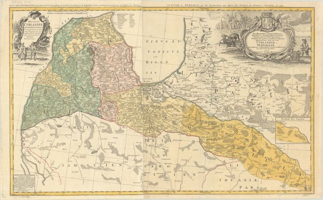
This large two-sheet map covers much of present-day Latvia in fine detail, extending to show part of northern Lithuania as well. It centers on Riga and spans from Libau (Liepaja) and Memel (Klaipeda) on the Baltic coast east to part of Livonia and Duhnaburg (Daugavpils). Political divisions, towns and cities, rivers, lakes, and forests are located. A small inset on the eastern sheet shows more of the Duchy of Semigallia. A key identifies various types of towns and cities and a Sunday prayer in the now-extinct Curonian language appears at bottom left. The title cartouche on the eastern sheet includes a coat of arms for the Duchy of Courland and Semigallia, a fisherman, a dense wood, and a bear attacking a deer. The cartouche on the western sheet features two figures in local dress. Cartography is credited to Johann Christoph Barnickel. Each sheet has an alternate French title above the neatline: Le Duche de Courlande... (western sheet) and Le Duche de Semgalle... (eastern sheet). On 2 sheets, joined.
References:
Condition: B+
Full contemporary color, issued folding on a sheet with an Elias Kutter watermark. There is very light toning and some small areas of printer's ink residue on the eastern sheet. There are a few tiny rust spots, a couple of minor edge tears that have been closed with archival tape on verso, and an archival repair to an abrasion in the border at bottom.