Subject: Gulf of Riga
Period: 1600 (circa)
Publication: Le Nouveau Miroir des Voiages Marins de la Navigation de la Mer Occidentale & Orientale
Color: Black & White
Size:
20.3 x 13.1 inches
51.6 x 33.3 cm
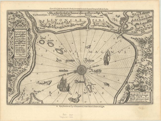
This rare and beautifully engraved sea chart depicts the Gulf of Riga. Within the water there is navigational information such as islands, soundings, and anchorages along with decorative elements like sailing ships and massive fish. An ornate compass rose radiating rhumblines orients north to the left. The coast is lined with graphic renderings of topography, architecture, and livestock. Riga, Pernout (Parnu), Tucken (Tukums), and Sales (Salacgriva) are among the cities identified along the coast. The chart is further embellished by elaborate title and distance scale cartouches and a coastal perspective along the top. The map is from a French text edition of the Spieghel der Zeevaerdt, the first detailed atlas of charts covering the coastlines of Europe, originally published in Dutch in 1584-85. In addition to the Dutch and Latin titles on the map itself, an alternate French title appears along the upper neatline: Carte de la Coste Maritime de Lifland, Contentat le Circuit du Grand Seing ou Golfe de Ryghe. Waghenaer's charts are renowned for their fine engraving by the best craftsmen of the period, including Theodore de Bry and the Doetecum brothers. This map was engraved by Joannes Doetecum. French text on verso.
References: Koeman, Wag 11 A #37d.
Condition: A
A dark impression with a printer's crease at left, a few minor spots, and minor marginal soiling.