Subject: Lolland & Falster, Denmark
Period: 1700 (circa)
Publication:
Color: Hand Color
Size:
20.8 x 16.1 inches
52.8 x 40.9 cm
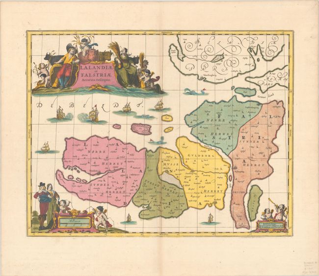
This very decorative copper plate map depicts Lolland and Falster. It extends to include the southern portion of Sjaelland as well as numerous smaller islands like Femo, Asko, and Fejo. The cities of Praesto, Wordingborg, Stubbekoping, Nykoping, Nysted, Saxkoping, Maribo, Rodby, and Naxkow are located. The ornate map is embellished with sailing ships, sea monsters, and three superb cartouches. The title cartouche is surrounded by figures of peasants and their cattle; the distance scale cartouche features aristocrats in their finery and putti with surveying tools; and the imprint cartouche is mounted by two putti. The plate was originally engraved by Jan Jansson. After his death it was inherited by his son-in-law, known as Jansson-Waesberg, who added a graticule and published it in conjunction with Moses Pitt. The map was then acquired by Pieter Schenk and Gerard Valck, who added more graticule lines and updated the imprint at bottom right.
References: cf. Van der Krogt (Vol I) #1541:1.2.
Condition: B+
A sharp impression on a bright sheet with full contemporary color that has been partially refreshed. There is very light toning along the centerfold and a tiny tear adjacent to the centerfold that has been closed on verso with archival tape.