Subject: Tournai, Belgium
Period: 1599 (circa)
Publication: Civitates Orbis Terrarum, Vol. IV
Color: Hand Color
Size:
17.2 x 14.4 inches
43.7 x 36.6 cm
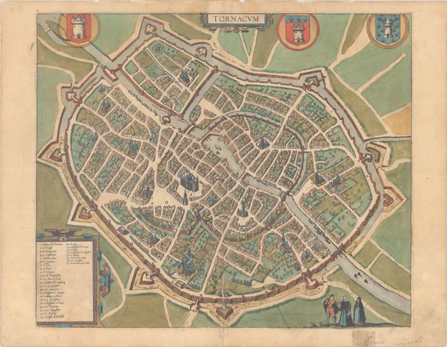
Braun & Hogenberg's Civitates Orbis Terrarum or "Cities of the World" was published between 1572 and 1617. Within the six volumes, 531 towns and cities were depicted on 363 plates, providing the reader with the pleasures of travel without the attendant discomforts. Braun wrote in the preface to the third book, "What could be more pleasant than, in one's own home far from all danger, to gaze in these books at the universal form of the earth . . . adorned with the splendor of cities and fortresses and, by looking at pictures and reading the texts accompanying them, to acquire knowledge which could scarcely be had but by long and difficult journeys?" Braun and Hogenberg incorporated an astonishing wealth of information into each scene beyond the city layout and important buildings. The plates provide an impression of the economy and prominent occupations, and illustrate local costumes, manners and customs.
This beautiful bird's-eye plan shows the historic Belgian town of Tournai as viewed from the south. Thirty locations in the plan are located by a numbered key, including the Notre-Dame Cathedral, an architectural standout. The plan is decorated with two strapwork cartouches, three heraldic crests, and a trio of costumed figures in the foreground. Latin text on verso, published in either 1599 or 1612.
References: Fussel, p. 281; Van der Krogt (Vol. IV) #4435.
Condition: B+
A sharp impression with full contemporary color on a lightly toned sheet. There is an archivally repaired 2" centerfold separation at bottom with minute loss, and archival repairs to a couple short edge tears in the upper margin, one of which just enters map image. In the margins there is light soiling and staining from an old tape repair on verso.