Subject: Eastern Europe, Russia
Period: 1548 (circa)
Publication: Geografia di Claudio Ptolemo Alexandrino
Color: Black & White
Size:
6.8 x 5 inches
17.3 x 12.7 cm
Claudius Ptolemy was a mathematician, astronomer and geographer who worked in Alexandria, then a part of the Roman Empire, in the 2nd century AD. One of the most learned and influential men of his time, his theories dominated both astronomy and geography for nearly 1500 years. His writings were kept alive by Arabic scholars during the Middle Ages and reemerged in Europe during the Renaissance. The birth of printing led to wide dissemination of his great works on astronomy and geography. There were a number of editions of his Geographia beginning in 1477. These early editions contained maps based on his original writings, known as Ptolemaic maps. As geographic knowledge increased with the explorations of Columbus, Magellan, Cabot and others, maps of the New World were added, and maps of the Old World were revised. Ptolemy's Geographia continued to be revised and published by some of the most important cartographers including Martin Waldseemuller, Sebastian Munster, Giacomo Gastaldi, Jodocus Hondius, and Gerard Mercator (whose last edition was published in 1730).
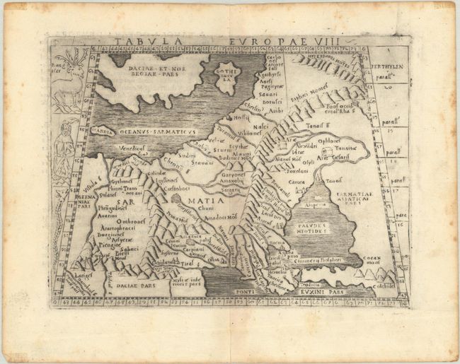
This charming small Ptolemaic map depicts Eastern Europe, known in ancient times as Sarmatia, encompassing the region between the Baltic and Black seas and between the Vistua and Volga rivers. The map is typically Ptolemaic - set within a trapezoidal frame with rope-like mountain ranges and boldly engraved rivers. Gastaldi's edition of Ptolemy was the earliest pocket atlas and marked the shift from woodcut maps to maps engraved on copper. Along the left edge of the plate are illustrations of a reindeer, a robed figure, and a serpent. Italian text on verso.
References:
Condition: B+
A dark impression with printer's ink residue and light toning along the centerfold. Light foxing and tape stains are confined to the sheet's edges, well away from map image.