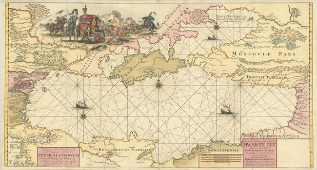
Subject: Black Sea
Period: 1709 (circa)
Publication:
Color: Hand Color
Size:
38.6 x 20.8 inches
98 x 52.8 cm
This superb and rare map of the Black Sea is one of the more decorative maps of the region. The large vignette within present-day Ukraine represents the Azov campaigns between 1695–1696, in which Peter the Great aimed to capture the Turkish fortress of Azov from the Ottoman Empire in order to gain access to the Black Sea. Although the siege in 1695 failed, the Russians were finally successful in capturing the fort in 1696. Azov (here "Azak") is prominently depicted along the Don River at top right. The Sea of Azov is labeled in Latin, French, Italian, Russian and Polish. The Sea of Azov and Black Sea are adorned with sailing ships and compass roses. The surrounding lands are well mapped with details of rivers, mountains, forests, and key cities. The map is dedicated to Peter the Great by Johannes van Keulen. Printed on two joined sheets, as issued.
References: Koeman, KEU 28 [186].
Condition: B+
A sharp impression on bright sheets with the watermark of Pieter van der Ley, issued folding. There is minor offsetting and soiling, and a few small spots. There are professional repairs to a short centerfold separation at bottom and to two 1" tears also at bottom. There are a few minute fold separations confined to the blank margins.