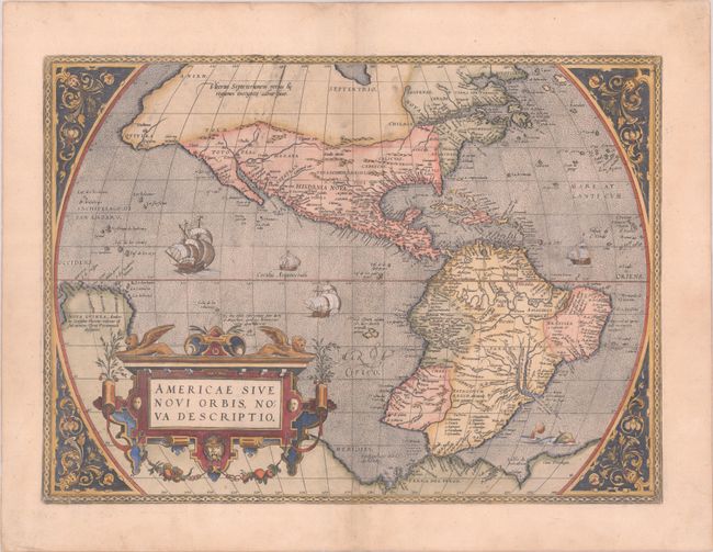
Subject: Western Hemisphere - America
Period: 1575 (published)
Publication: Theatrum Orbis Terrarum
Color: Hand Color
Size:
20.1 x 14.6 inches
51.1 x 37.1 cm
This is one of the most famous maps of America, and one that had enormous influence on the future cartography of the New World. Frans Hogenberg engraved this map, and it is primarily based on Gerard Mercator's great multi-sheet world map of 1569. The most recognizable features of the map are the bulbous Chilean coastline and the exaggerated breadth of the North American continent. North America shows a lengthy St. Lawrence River reaching across the continent to nearly meet the fictitious, westward flowing Tiguas Rio. The strategically placed title cartouche hides the unknown South Pacific and therefore most of the conjectural great southern continent, which is shown attached to both New Guinea and Tierra del Fuego.
This is from the uncommon first plate (third state), published in the 1575 Latin edition. This plate had a relatively short life and was published only between 1570 and 1575. This rare state is evidenced by the number 230 missing from the longitudinal scale at top, which was removed as a result of reworking the plate. This plate quickly developed another crack and was subsequently replaced by a new plate for the 1579 edition.
References: Burden #39.3; Goss (NA) #11; Van den Broecke #9.3.
Condition: B+
A crisp impression on paper with the crossed arrows watermark commonly found on Ortelius maps. There is a repaired 2" centerfold separation and small sliver of loss (1.75" x 0.25") along the lower centerfold that has been professionally reinstated with image drawn in facsimile.