Subject: Red Sea
Period: 1787 (circa)
Publication: Atlas Universel
Color: Hand Color
Size:
8.4 x 31 inches
21.3 x 78.7 cm
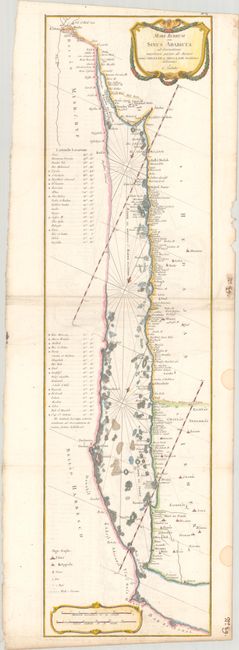
This nicely engraved French chart of the Red Sea is based on the Carsten Niebuhr map first published in Beschryving van Arabie. The chart extends from Cairo south to Aden and names several cities, towns, and settlements of various sizes, most of them concentrated along the eastern coastline. A table at left lists latitudes for various locations. Rhumb lines fill the sea, and hazards, anchorages, and small islands are noted. There is an ornate title cartouche at top right and a distance scale cartouche at bottom left. The scientific and relatively accurate maps from Carsten Niebuhr's travels with the Danish Arabia expedition (1761-67) were highly influential, copied by many top cartographers, including Bonne, Cary, and Lotter.
References: Mickwitz & Miekkavaara #179-88.
Condition: B+
Issued folding on a sheet with a "1784" watermark. There is light extraneous creasing and offsetting, and a few dampstains along the right edge of the sheet, well away from map image.