Subject: Central Asia
Period: 1753 (dated)
Publication:
Color: Hand Color
Size:
19.3 x 9.3 inches
49 x 23.6 cm
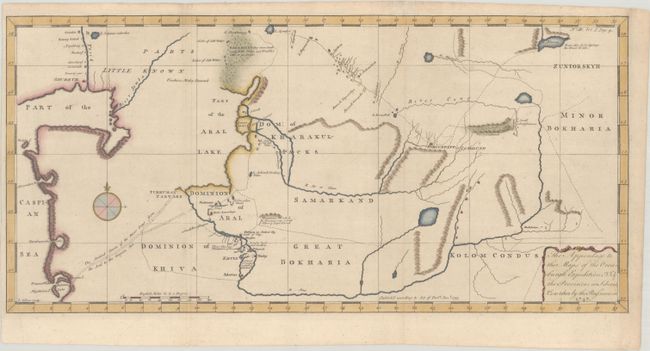
This uncommon map covers the region mapped by the Orenburg Expedition (1734-44), a Russian expedition to build forts along the border with Bashkortostan (or Bashkiria) and open trade with bordering areas in Central Asia. The expedition led to the creation of the Orenburg Oblast. The map shows present-day Kazakhstan and Uzbekistan and vicinity, and spans from the northeastern shores of the Caspian Sea east to Minor Bokharia. Ghureve (now called Atyrau) is identified at the mouth of the R. Yaeik (Ural River), and several towns and cities are named around the R. Amo (Amu Darya River). The cities of Turkistan and Tashkent are shown side-by-side, despite being 180 miles apart. The Aral Lake is incompletely mapped, with only a defined eastern shore. There are interesting notes across the landscape, including "Mountains on which the Persians say is Gold & Silver & Lapis Lazuli" and "Cherpan an Antient City made of Clay." The map is adorned with a compass rose capped by a fleur-de-lis and a decorative title cartouche. A fascinating look at the region as it was being mapped, full of conjecture and vast stretches of unknown land.
References:
Condition: A
A crisp impression issued folding, now flat, with marginal soiling. Narrow left margin.