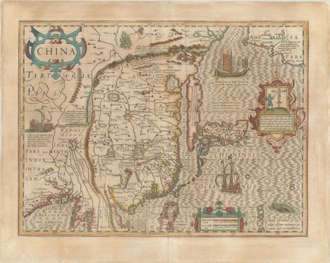
Subject: China, Korea & Japan
Period: 1639 (circa)
Publication: Nouveau Theatre du Monde
Color: Hand Color
Size:
18.1 x 13.5 inches
46 x 34.3 cm
Besides China, this map depicts Korea as an elongated island and Japan on the Ortelius-Teixeira model. The map contains rudimentary geographical information, as there was very little actually known of the region during the early part of the seventeenth century. The interior of China is dominated by several large lakes, and the mythical Chiamai Lacus forms the headwaters of five large rivers in northeastern India. Fourteen provinces are named. The floating figure in the lake in Sancii is a reference of the flooding caused by the 1556 Shaanxi earthquake, the deadliest recorded earthquake in history. The northwest coastline of America appears in the upper right corner with a notation that refers to the Tartar hordes that inhabit the region. The map is beautifully engraved with a moiré patterned sea and richly embellished with strapwork cartouches, a deer, a fox, a sea monster, a European and a Japanese ship, and a unique wind-powered wagon. In one cartouche, a scene depicts the Japanese persecution of a Christian missionary, probably a reference to the martyrdoms in Nagasaki in 1597. French text on verso, published between 1639-44.
References: Caboara #11; Van der Krogt (Vol. I) #8410:1A.
Condition: B
Full contemporary color on a toned sheet with a professionally repaired centerfold separation that just crosses the neatline at bottom.