Subject: Western Hemisphere - America
Period: 1740 (circa)
Publication:
Color: Hand Color
Size:
23.1 x 19.1 inches
58.7 x 48.5 cm
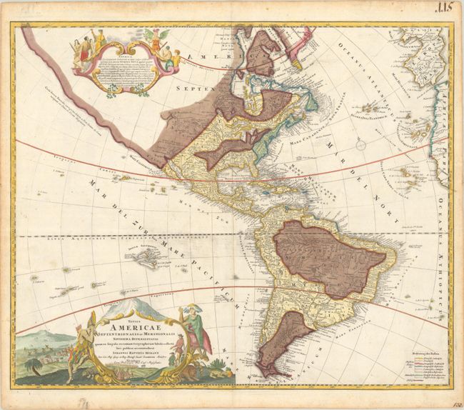
This attractive map is a revision of the elder Homann's 1710 map of the Americas. After his death in 1724, his son (Johann Christoph Homann) re-engraved the plate to correct the western coastline of North America, shown here extending very far west and north, with very little detail. The coastline is labeled Costa Terrae Borealis and is attributed to the reports by João da Gama, who sighted land while traversing the Pacific Ocean in 1589-90. California is no longer shown as an island, although the remnants of the interior sea can be seen near the Pais de Moozemleck, where a river nearly connects with the Mississippi River system, hinting at the possibility of a Northwest Passage. The Great Lakes are taking shape, being actively explored by the French fur traders and the Hudson Bay Company. The Solomon Islands are prominently placed in the Pacific, considerably too far to the east. The map is decorated with two large pictorial cartouches; the one at top shows natives worshiping a fearsome demon at the right, while at left they listen placidly to a priest. The lower cartouche also features the landscape and native fauna.
Presumably, the younger Homann's re-engraved plate became damaged, as a third plate was engraved, which is easily identifiable by the eastern coast of Spain appearing in the third plate. Nearly all other details are identical in the third plate, although a few place names are missing, such as Taos, and fewer mountains and forests are illustrated. This example is the third plate.
This example is particularly unique, as it has been transformed into a thematic map to depict the various religions practiced in the western hemisphere. A separately engraved, colored key has been pasted onto the sheet at lower right to identify Roman Catholic, Evangelical Lutheran, Evangelical Reformist, and Pagan regions. This is the first time we have seen this thematic edition.
References:
Condition: A
Contemporary color in the map with later color in the cartouches, on a bright sheet with some printer's ink residue in the Pacific and light toning along the edges of the sheet.