Catalog Archive
Auction 202, Lot 661

"Carte de l'Ile de Java: Partie Occidentale, Partie Orientale, Dressee tout Nouvellement sur les Memoires les Plus Exacts; avec une Table des Principales Villes de cette Ile...", Chatelain, Henry Abraham

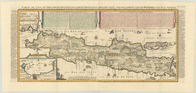
Subject: Java, Indonesia

Period: 1719 (published)

Publication: Atlas Historique, Tome V

Color: Hand Color

Size:
31.3 x 14.2 inches
79.5 x 36.1 cm
Download High Resolution Image
(or just click on image to launch the Zoom viewer)

This important large-scale chart of Java is one of the finest 18th century maps of the island. The map graphically depicts rice fields, mountains, forests, cities, villages and even elephants. A large inset features the important Dutch trading capital of Batavia (present day Jakarta). The superb detail is complemented by an extensive textual description (French) contained in drapery style cartouches and side panels. Two sheets joined as issued, measurement includes the title and text outside the map border.

References: Koeman, Cha 6 #9; Parry, p. 197.

Condition: A

A sharp impression, issued folding on bright sheets with a Strasbourg bend & lily watermark. There is minor marginal foxing and a soft crease at top right.

Estimate: $900 - $1,100

Sold for: $650

Closed on 2/12/2025

Archived