Subject: Western Hemisphere - America
Period: 1762 (dated)
Publication: Atlas Moderne
Color: Hand Color
Size:
17.7 x 12.1 inches
45 x 30.7 cm
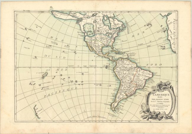
A huge, imaginary Sea of the West and hints of a possible Northwest Passage dominate this fine map of the Americas. Alaska is shown in an early configuration with a rough shape incorporating the Aleutians and notations concerning the coastline discoveries in 1741 by the Russians. In North America, the British colonies are shown confined east of the Allegheny Mountains, French Louisiana takes in the Great Lakes and most of the interior, and Spain controls an oversized Florida, New Mexico, and Mexico. South America’s coastlines are well-mapped with much of the interior reflecting early exploration interspersed with speculation relating to the continued searches for the untold riches of El Dorado. There are several islands shown in the South Pacific and just the western coastline of New Zealand. This interesting and handsome map is embellished with a decorative rococo-style title cartouche.
References: McGuirk #108.
Condition: A
A crisp impression with contemporary color on a watermarked sheet with minor toning along the centerfold at bottom and several tiny worm holes, two of which are in the image.