Subject: Western Africa
Period: 1727-1748 (dated)
Publication:
Color: Hand Color
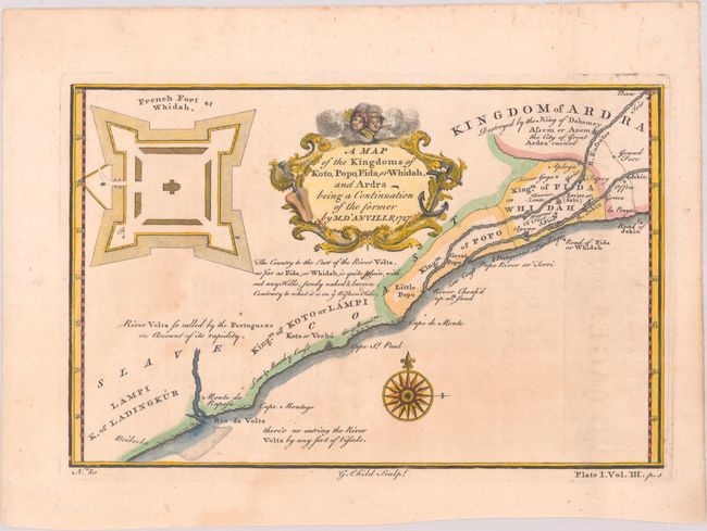
A. A Map of the Kingdoms of Koto, Popo, Fida, or Whidah, and Ardra Being a Continuation of the Former, by Jean Baptiste Bourguignon d'Anville, from A New General Collection of Voyages and Travels, dated 1727 (9.0 x 5.9"). This map details the Slave Coast in western Africa, extending along the coasts of present-day Ghana, Togo, and Benin and showing the kingdoms of Ladingkur, Koto, Popo, Ardra, and Fidah or Whidah. It includes locations of rivers, towns, and forts, as well as historical and practical information such as dangerous landing, a description of the landscape, and the origin of the river Volta's name. In the top left corner, there is an enlarged depiction of the French Fort at Whidah. Engraved by G. Child and published in Volume III of A New General Collection of Voyages and Travels...Comprehending Every Thing Remarkable in its Kind, in Europe, Asia, Africa, and America (1745-47). The work is believed to have been edited by Bradock Mead (John Green), although the collection is more commonly attributed to the publisher, Thomas Astley. Reference: Shirley (BL Atlases) G.ASTL-1a #35. Condition: A sharp impression with light dampstaining and faint offsetting from an opposing page of text. (B+)
B. Vue Sud du Fort de Tantumquerri, par Smith, by Jacques Nicolas Bellin, from Histoire Generale des Voyages, circa 1754 (11.3 x 7.7"). View of a fort in the town of Tantum along the Gold Coast, with an inset showing the plan of the fort. Drawn and engraved by Chedel. Condition: A nice impression with minor toning along the centerfold and sheet's edges and a small spot. (A)
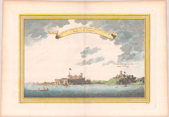
C. Vue du Chateau de St. Georges de Mina, Tiree de Barbot et de Dapper, by Jacques Nicolas Bellin, from Histoire Generale des Voyages, circa 1754 (11.3 x 7.6"). View of Elmina Castle, the first trading post built on the Gulf of Guinea. Fort Coenraadsburg, built to protect the castle, is seen to the right. Drawn and engraved by Chedel. Condition: A crisp impression with a fleur-de-lis watermark and a hint of toning along the centerfold and sheet's edges. (A)
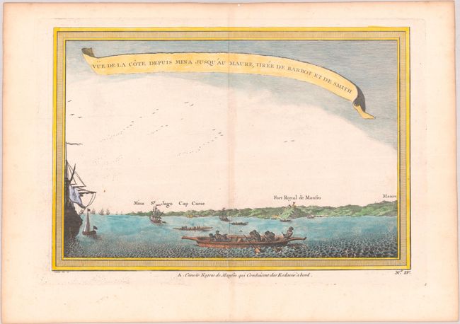
D. Vue de la Cote Depuis Mina Jusqu'au Maure, Tiree de Barbot et de Smith, by by Jacques Nicolas Bellin, from Histoire Generale des Voyages, circa 1754 (11.2 x 7.6"). A view showing the Gold Coast from Mina to Maure, with a canoe in the foreground. Drawn and engraved by Chedel. Condition: On paper with a fleur-de-lis watermark. There is a hint of toning along the centerfold and sheet's edges, and a couple tiny, unobtrusive spots. (A)
References:
Condition:
See description above.