Subject: North America
Period: 1832 (dated)
Publication: Stieler's Hand-Atlas
Color: Hand Color
Size:
14.4 x 11.5 inches
36.6 x 29.2 cm
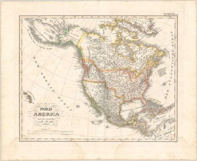
The United States and Great Britain established in 1818 joint claim over the Oregon Territory - the region north of Spanish controlled Upper California up to the southern boundary of Russia's Alaska Territory at North latitude 54°40'. By the late 1830's this arrangement was beginning to fall apart.
In the 1840's the expansionist Democrats, including their 1844 presidential candidate, James Polk, claimed the entire region for the United States. Their expansionist desires were expressed by Polk's famous campaign slogan, "Fifty-four Forty or Fight!" The slogan also became a rally cry for Americans desiring to settle the territory. Following Polk's election, the dispute was resolved by the 1846 Treaty of Oregon, which struck a compromise that fixed the U.S./Canadian boundary at 49º North.
This attractive German map of North America names plenty of towns and cities, rivers, forts, Indian tribes, and features good topographical detail. Mexico is in control of the Southwest including Texas, which is named along with San Antonio. Oregon Territory extends well into present-day British Columbia, reflecting U.S. interests in the region. The Midwest, east of the Rocky Mountains, is Missouri Territory while Wisconsin is labeled Northwest Territory. The map extends west to include the Sandwich Islands, which is unusual for a map of this period. Engraved by L. Thiel and published in Stieler’s Hand Atlas.
References:
Condition: B
Contemporary outline color with scattered foxing and two dampstains at bottom.