Subject: North America, Texas
Period: 1846 (dated)
Publication: Geographie Universelle
Color: Hand Color
Size:
9.2 x 12.2 inches
23.4 x 31 cm
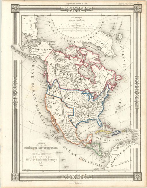
The United States and Great Britain established in 1818 joint claim over the Oregon Territory - the region north of Spanish controlled Upper California up to the southern boundary of Russia's Alaska Territory at North latitude 54°40'. By the late 1830's this arrangement was beginning to fall apart.
In the 1840's the expansionist Democrats, including their 1844 presidential candidate, James Polk, claimed the entire region for the United States. Their expansionist desires were expressed by Polk's famous campaign slogan, "Fifty-four Forty or Fight!" The slogan also became a rally cry for Americans desiring to settle the territory. Following Polk's election, the dispute was resolved by the 1846 Treaty of Oregon, which struck a compromise that fixed the U.S./Canadian boundary at 49º North.
This decorative map presents the northwest boundary of the United States extending well into present-day British Columbia, reflecting U.S. interests in the Oregon Boundary Dispute. Despite the erroneous coloring, the map also presents an Independent Republic of Texas with Austin noted as the capital (the engraved lines correctly show Texas as a separate entity). Mexico is in control of the Southwest and California. Indian Territory is here called Distict d'Ozark and Alaska is Amerique Russe. The map is decorated by a picture-frame style border and fancy scroll titling. Engraved by Charles Smith, this edition is revised to 1846.
References:
Condition: A
On a bright sheet with contemporary outline color.