Current Auction
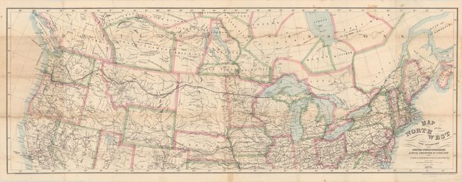
"Map of the Northwest from Explorations by the United States Engineers & Royal Engineers of England and Union & Northern Pacific R.R. Surveys", Bien, Julius
Subject: Northern United States & Canada
Period: 1870 (dated)
Publication:
Color: Hand Color
Size:
41.2 x 15.2 inches
104.6 x 38.6 cm
Download High Resolution Image
(or just click on image to launch the Zoom viewer)
(or just click on image to launch the Zoom viewer)
This uncommon map details the route of the Northern Pacific Railway from Lake Superior to Portland, Seattle and Olympia. The map stretches from New England to the Pacific Northwest, south to include San Francisco and Denver, and north into Canada showing most of British Columbia and all of Alberta, Saskatchewan, Winnipeg, Moose, Bittibee and most of James Bay. The map is remarkably detailed with all rails throughout the area delineated as well as the watersheds, wagon roads and many towns named. Isothermal lines give the mean annual temperature in 10°F increments. Interesting notations include the location of coal in several places, the winter home of buffaloe, and various land types including pasture and timber. One notation in northeastern Montana states the region is "Wide & fertile Valley well timbered." Lithography by the N.Y. Lithographic, Engraving and Printing Co. of Julius Bien. The map is hand colored in outline, a rarity for the Julius Bien company.
References:
Condition: B
Issued folding and now flat with numerous small fold separations closed on verso with old tape. There is some minor loss at the fold junctions and light toning at left where the map was previously folded into the book.
Estimate: $190 - $220
Current High Bid:
$0
Reserve: Reserve Not Met
Next Bid: $95
Bid Increments
$50 - $99$5
$100 - $249$10
$250 - $499$25
$500 - $999$50
Terms & Conditions