Current Auction
One of the Most Detailed and Important 19th-Century Maps of the American Northwest
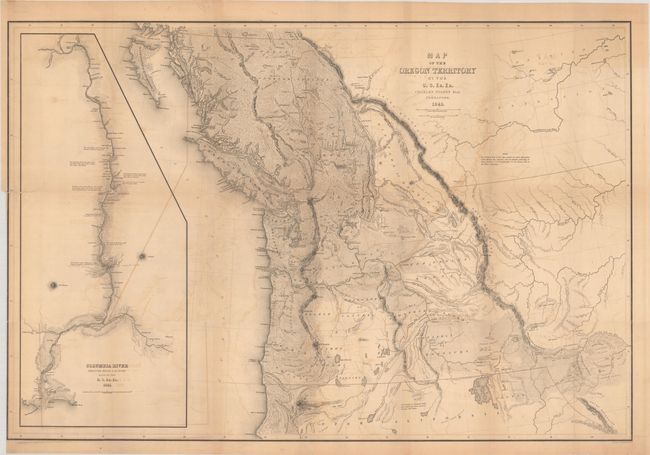
"Map of the Oregon Territory by the U.S. Ex. Ex.", Wilkes, Charles
Subject: Northwestern United States & Canada
Period: 1841 (dated)
Publication: Narrative of the United States Exploring Expedition…
Color: Black & White
Size:
34.1 x 22.9 inches
86.6 x 58.2 cm
Download High Resolution Image
(or just click on image to launch the Zoom viewer)
(or just click on image to launch the Zoom viewer)
The United States and Great Britain established in 1818 joint claim over the Oregon Territory - the region north of Spanish controlled Upper California up to the southern boundary of Russia's Alaska Territory at North latitude 54°40'. By the late 1830's this arrangement was beginning to fall apart. In the 1840's the expansionist Democrats, including their 1844 presidential candidate, James Polk, claimed the entire region for the United States. Their expansionist desires were expressed by Polk's famous campaign slogan, "Fifty-four Forty or Fight!" The slogan also became a rally cry for Americans desiring to settle the territory. Following Polk's election, the dispute was resolved by the 1846 Treaty of Oregon, which struck a compromise that fixed the U.S./Canadian boundary at 49º North.
According to Wheat, this important map was "in many respects the most detailed of this extensive area yet published, and for the main Oregon region and the Hudson's Bay Company territories to the north it was an accurate, really quite extraordinary, map." The map covers the entire region west from the Black Hills, north to above the 50th parallel and south to the Sacramento River. The United States Exploring Expedition did not enter the Great Basin or any part of the Snake River basin. Instead Wilkes relied on other sources including Jedediah Smith and oral information from Hudson Bay trappers he met on the Columbia River. Although the map contains several errors, the areas of today's Oregon, Washington, and Idaho are remarkably well mapped. According to Wheat the map had much influence on later maps of this region. It was a major contribution to American cartography and the most detailed map of the region north of the Sacramento River. Wilkes supported the view of Senator Lewis Linn that the boundary of the American claim should be 54° 40' N, commonly referred to as "Fifty-Four Forty or Fight" dispute with Britain. This map was used to support his claim, which was based on 'topographical' grounds and was instrumental in setting the scene for American interests in the territory. Includes a large inset of the Columbia River from Ft. Walla Walla to its mouth, where one of Wilkes' ships, the Peacock, was lost on the famous Columbia Bar. This map is considered one of the more important maps of the Northwest region after the Lewis & Clark expedition.
See also lot 784 for Carl Wheat's Mapping the Transmississippi West that describes this map.
References: Wheat (TMW) #457.
Condition: B
Issued folding on a lightly toned sheet with some offsetting and a binding trim at lower left. A 2.25" binding tear and several tiny separations at the fold junctions have all been closed on verso with archival materials.
Estimate: $1,400 - $1,700
Current High Bid:
$1,000
Reserve: Reserve Met
Next Bid: $1,100
Bid Increments
$1,000 - $2,499$100
$2,500 - $4,999$250
$5,000 - $9,999$500
$10,000 - $24,999$1,000
Terms & Conditions