Current Auction
"United States of America Corrected & Improved from the Best Authorities", Warner, Benjamin
Subject: United States
Period: 1820 (dated)
Publication: Atlas to Guthrie's Geography
Color: Hand Color
Size:
24.8 x 16.3 inches
63 x 41.4 cm
Download High Resolution Image
(or just click on image to launch the Zoom viewer)
(or just click on image to launch the Zoom viewer)
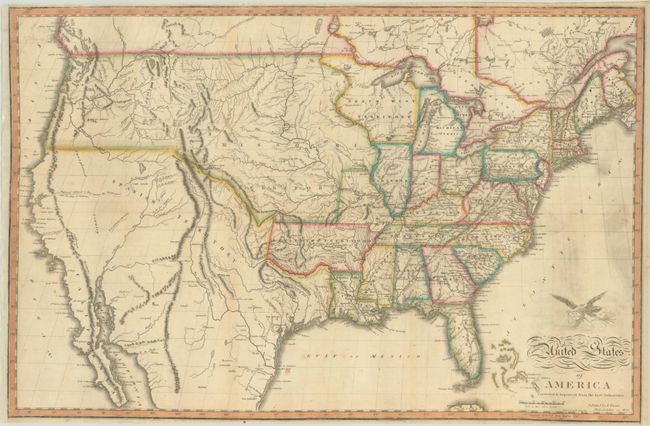
This is one of the first separately issued maps of the United States to stretch from sea to shining sea, and is visually very similar to the Melish maps that extend as far as the Rocky Mountains. In its depiction of the West, the map pulls from Lewis and Clark, Humboldt, Pike, and Melish. According to Wheat, Warner's map was part of a wave of maps that propagated the mythical rivers of the Great Basin that "would plague everybody, even more than did the older tale of the Island of California." The R. Bonaventura flows into a partial lake in the Valle Salado. To its west is a conjectural river that supposedly links the Buenaventura to San Francisco Bay. The map borrows from Melish a notation that marks where "Clarks Canoes stop 3000 miles from the Mississippi." Spanish Territory is separated from the United States by the "boundary of the United States according to the Florida Treaty." In Texas there are a few place names including San Antonio and Ft. Matagorda, but Galvezton is incorrectly place west of Sabine Lake. Missouri Territory takes in the entire northern plains region from the Mississippi to the Pacific Northwest. Arkansaw Territory is shown at its largest extent. Today's Minnesota and Wisconsin are here a part of North West Territory. As with many editions of the Melish map of the United States, there is a vignette of an eagle carrying a shield emblazoned with the stars and stripes above the script title. Engraved by Hugh Anderson.
See also lot 784 for Carl Wheat's Mapping the Transmississippi West that describes this map.
References: Phillips (Maps) p. 881; Wheat (TMW) #341.
Condition: B+
Issued folding and now flattened and backed with tissue to repair a couple of small holes along the western U.S./Canada border. There are several printer's creases at bottom and some minor soiling. Remargined at left.
Estimate: $1,200 - $1,500
Current High Bid:
$0
Reserve: Reserve Not Met
Next Bid: $600
Bid Increments
$500 - $999$50
$1,000 - $2,499$100
$2,500 - $4,999$250
$5,000 - $9,999$500
Terms & Conditions