Current Auction
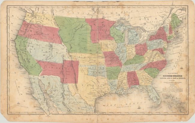
"Map of the United States Canada and a Part of Mexico. To Illustrate Olney's School Geography", Robinson, D.F. & Co.
Subject: United States
Period: 1844 (dated)
Publication:
Color: Hand Color
Size:
17.7 x 10.8 inches
45 x 27.4 cm
Download High Resolution Image
(or just click on image to launch the Zoom viewer)
(or just click on image to launch the Zoom viewer)
While dated 1844, the map is circa 1853 with the appearance of Washington Territory and New Mexico's border on the Gila River. Texas is in its preset-day configuration. To its west are New Mexico and Utah territories in their largest extents, and both Oregon and Washington territories extend to the Continental Divide. A huge Nebraska Territory extends from the Missouri River to the Rockies, while Kansas extends into present-day eastern Colorado. Minnesota Territory includes the eastern Dakotas. Copyright below neatline by D.F. Robinson. Drawn and engraved by Sherman & Smith, N.Y.
References:
Condition: B
Contemporary color with foxing and soiling, mostly along the sheet edges. A short centerfold separation at bottom has been closed on verso with archival tape. The bottom sheet corners are chipped in the blank margins.
Estimate: $180 - $220
Current High Bid:
$90
Reserve: Reserve Not Met
Next Bid: $95
Bid Increments
$50 - $99$5
$100 - $249$10
$250 - $499$25
$500 - $999$50
Terms & Conditions