Current Auction
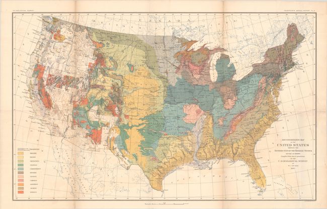
"Reconnoissance Map of the United States Showing the Distribution of the Geologic System So Far as Known...", U.S. Geological Survey (USGS)
Subject: United States, Geology
Period: 1893 (dated)
Publication: U.S. Geological Survey Fourteenth Annual Report
Color: Printed Color
Size:
28.4 x 17.6 inches
72.1 x 44.7 cm
Download High Resolution Image
(or just click on image to launch the Zoom viewer)
(or just click on image to launch the Zoom viewer)
This is the second geological map of the United States published by the USGS and prepared by William John McGee. The legend names and color-codes thirteen different geological types in twelve major groups. Compared to the first USGS edition this map presents new geological information in portions of California and the Pacific Northwest. But the map continues to show wide areas of unmapped territory in the western U.S., thus continuing the Survey's policy of caution in displaying areas having questionable or incomplete geological data. This approach contrasts sharply with the geological maps of academics such as C.E. Hitchcock, who prepared fully colored maps dating back to the 1870s. On this map the geography of the King, Hayden, Powell, and Wheeler surveys are evident in the west.
References:
Condition: B+
Issued folding with light color offsetting and light dampstaining that enters the map image at right.
Estimate: $200 - $230
Current High Bid:
$0
Reserve: Reserve Not Met
Next Bid: $100
Bid Increments
$100 - $249$10
$250 - $499$25
$500 - $999$50
$1,000 - $2,499$100
Terms & Conditions