Current Auction
A Map with Popular Cartographic Myths and Unique Embellishments
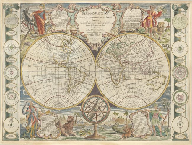
"Mappe-Monde Carte Universelle de la Terre Dressee sur les Relations les Plus Nouvelles, Soumises aux Observations Astronomiques de l'Academie Royale des Sciences...", Nolin/Denis
Subject: World
Period: 1788 (dated)
Publication:
Color: Hand Color
Size:
25.5 x 18.9 inches
64.8 x 48 cm
Download High Resolution Image
(or just click on image to launch the Zoom viewer)
(or just click on image to launch the Zoom viewer)
This is an uncommon and striking map of the world in two hemispheres. First published in 1755, this edition has been updated based on new discoveries in the Pacific, and yet still contains several popular cartographic myths. In the North Pacific, the coastline of North America stops at C. Blanc with dashed, conjectural outlines further north. A large Sea of the West (Mer de l'Ouest) is shown extending nearly to the Mississippi River and to a second river that flows to Hudson Bay. A nearby note explains that the rivers, islands and lakes in that region are shown conjecturally while they await verification. In the northwest Pacific, Hokkaido doesn't yet appear, and in its place is a partially delineated island named Terre de la Compagnie (Company's Land). In the South Pacific, Australia is quite misshapen and still attached to Tasmania, however New Zealand is now entirely delineated, although the coastlines are still rudimentary. The tracks of numerous explorers fill the oceans, including Cook, Anson, Bougainville, and Furneaux.
In North America, there do not appear to be any changes since the 1755 edition. The British colonies (Colonies Angloises) are still shown along the East Coast and Lakes Superior, Michigan and Huron are still interconnected. There are only a few place names in the interior, including Quebec, Boston, Philadelphia, Charleston, St. Augustine, New Orleans, and Santa Fe.
Stunning vignettes representing the four continents fill the corners of the map, each with an allegorical figure presenting a cartouche containing descriptive text, accompanied by a native animal and set in an exotic landscape. Europe includes a horse and symbols of the arts, sciences and war. Africa wears an elephant-head as a hat and stands next to a lion, while Asia holds incense next to a camel. America wears a feathered costume and holds a bow, while a large dinosaur-like creature lays next to an odd-formed human creature that appears to be eating a round piece of fruit. The sides of the map are flanked with columns showing 10 astronomical diagrams of the sun, moon and planetary systems. An armillary sphere sits in the lower cusp of the map, and a grandly decorative title cartouche rests on the upper cusp.
References: McGuirk #49.
Condition: B+
A nice impression on a bright sheet with a "Tamizier Auvergne 1782" watermark. There is light soiling, some minor creasing, and a bit of show-through in the Pacific of some old manuscript notes on verso. The map has been trimmed to the neatlines and professionally remargined.
Estimate: $3,000 - $3,750
Current High Bid:
$0
Reserve: Reserve Not Met
Next Bid: $1,500
Bid Increments
$1,000 - $2,499$100
$2,500 - $4,999$250
$5,000 - $9,999$500
$10,000 - $24,999$1,000
Terms & Conditions