Current Auction
Prototypical Persuasive Map Relating to Highways and Airports
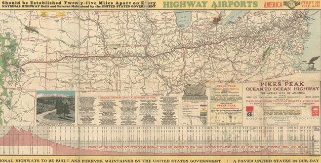
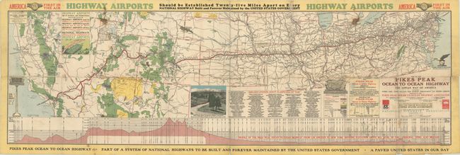
"Map of the Pikes Peak Ocean to Ocean Highway - The Appian Way of America Showing Every City, Town, Village and Hamlet Throughout Its Entire Length..."
Subject: United States
Period: 1924 (dated)
Publication:
Color: Printed Color
Size:
50.1 x 15.2 inches
127.3 x 38.6 cm
Download High Resolution Image
(or just click on image to launch the Zoom viewer)
(or just click on image to launch the Zoom viewer)
This fascinating early automobile map promotes a transcontinental highway from New York to California that bypasses the larger cities of Chicago and Denver, and instead travels through Las Vegas, Nevada, a town of only 3,000 at the time. Finding that “Highway Airports are of National and International Importance,” the map promotes highways connected with airports, with a banner “America First in the Air/ Highway Airports Should be Established Twenty-Five Miles Apart…” Features illustrations of a highway airport, Pikes Peak, and a long profile at bottom showing the elevation change along the route. Text at bottom markets the highway as "Part of a System of National Highways to be Built and Forever Maintained by the United States Government." The National Highways Association was an early and effective advocate for a federally funded auto road network. Created by John C. Mulford, Chief Cartographer for the Pikes Peak Ocean to Ocean Highway Association.
References:
Condition: B
Issued folding with light soiling, staining, and a couple of pencil notations. There are numerous fold separations closed on verso with old tape and some small losses mostly at the fold junctions.
Estimate: $160 - $190
Current High Bid:
$100
Reserve: Reserve Met
Next Bid: $110
Bid Increments
$100 - $249$10
$250 - $499$25
$500 - $999$50
$1,000 - $2,499$100
Terms & Conditions