Current Auction
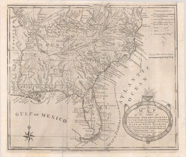
Rare First State of Purcell's Map Locating the Proposed State of Franklin
"A Map of the States of Virginia North Carolina South Carolina and Georgia Comprehending the Spanish Provinces of East and West Florida Exhibiting the Boundaries as Fixed by the Late Treaty of Peace Between the United States and the Spanish Dominions...", Purcell, Joseph
Subject: Southern United States, Franklin
Period: 1788 (dated)
Publication:
Color: Black & White
Size:
14.6 x 12.6 inches
37.1 x 32 cm
Download High Resolution Image
(or just click on image to launch the Zoom viewer)
(or just click on image to launch the Zoom viewer)
This fine map is a fascinating historical document of the United States following the Revolutionary War. It includes an early reference to the New State of Franklin in present-day eastern Tennessee. The map features a great amount of information, including boundaries claimed by the various Indian Nations and trading paths on the western frontier. It shows early settlements, including a Moravian Settlement in North Carolina, and the Cumberland Settlements in present-day Tennessee. At the top of the map, in the nascent Northwest Territory, the 7 Ranges denote the first application of the Public Land Survey System. Several bounty land grants are shown including the Ohio Company, Wabash Company, New Jersey Company, Illinois Company, and the Donation Lands of the Commonwealth of Virginia. A triangular shaped plot of land in the region of present-day West Virginia is labeled Indiana. This is the rare first state of Purcell's map, and only the second time this state has been listed with OWA. The first state was published in Jedidiah Morse's American Geography (1789) and The American Magazine Vol. I (August 1788), edited by Noah Webster, Jr.
In 1785, settlers in present-day western North Carolina and eastern Tennessee organized a state government to be named in honor of Benjamin Franklin, Franklinia or Frankland. Congress turned down their appeal but the state maintained a legislature and governor until 1788. This ephemeral state appeared on a small number of maps into the early part of the 19th century.
References: Baynton-Williams (TMC-72) p. 15, #2; Dotson & Baker (OWA) #3; McCorkle (18th C. Geography Books) #299-2; Sellers & Van Ee #1410; Wheat & Brun #491.
Condition: B+
A strong impression, issued folding on a paper with the watermark of C. & I. Honig. Remargined at right with old paper. A 4" binding tear at right has been closed on verso with archival materials. One of the nicest examples of this map that we have seen.
Estimate: $1,000 - $1,300
Current High Bid:
$550
Reserve: Reserve Not Met
Next Bid: $600
Bid Increments
$500 - $999$50
$1,000 - $2,499$100
$2,500 - $4,999$250
$5,000 - $9,999$500
Terms & Conditions