Current Auction
"[Untitled - Pl. XIII Map of Mississippi and Alabama]", Drury, Luke
Subject: Alabama & Mississippi
Period: 1822 (published)
Publication: A Geography for Schools...
Color: Hand Color
Size:
8.8 x 6.1 inches
22.4 x 15.5 cm
Download High Resolution Image
(or just click on image to launch the Zoom viewer)
(or just click on image to launch the Zoom viewer)
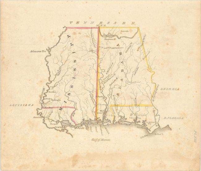
This small map was issued in Luke Drury's scarce A Geography for Schools, upon a Plan Entirely New, Consisting of an Analytical Arrangement of All the Great Features of Nature, Particularly Adapted to an Atlas of Forty Luminous and Concise Maps. Details are sparse including the river systems, some small mountains in the northern parts of these new states, several forts, and a few settlements including Hunstville, Mobile and New Orleans. There is no mention of Indian tribes despite this region being home to the Creek, Chickasaw and Choctaw tribes. The map also presents portions of southern Louisiana and West Florida, which would merge with East Florida to form Florida Territory that same year. According to Tooley's Dictionary of Mapmakers, this was Drury's only publication.
References: Phillips (Atlases) #279.
Condition: B
Contemporary outline color with scattered foxing and a dampstain along the bottom sheet edge, away from the map image.
Estimate: $140 - $170
Price: $100
Bid Increments
$50 - $99$5
$100 - $249$10
$250 - $499$25
$500 - $999$50
Terms & Conditions